|
||

|

|
|

|
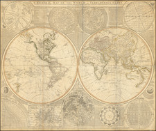
A Rare Early-16th-Century World Map. One of the Few Maps to be Based on Waldseemuller's Carta Marina.
Rare early map of the modern world, published by Oronce Fine in the 1535 edition of the Margarita Philosophica.
The map is a reduction of the very curious six-sheet world map published in Gregor Reisch's 1515 edition of the Margarita Philosophica. Some have suggested that this map was produced by Waldseemuller himself, based on the many similarities between that map and Waldseemuller's Carta Marina, which came out the year after.
Most recent scholarship and cataloging of this map have dated it to 1513, however, we believe this to be incorrect. Several factors influence our conclusion, the most prominent of which is the watermark being found exclusively on documents dated to between 1535 and 1536. A complete rationale for this updated dating will be provided further below.
The Margarita Philosophica
Reisch first issued his Margarita Philosophica in 1503. An encyclopedic handbook of science, medicine, music, natural history, and philosophy, the work was re-issued on a number of occasions in the 16th century. In the earliest editions, Reisch included a world map with either four windheads or twelve windheads, which did not include a depiction of the recent European discoveries in the New World.
Reisch was one of a group of southern German humanists, along with Martin Waldseemüller or Matthias Ringmann, who sought to move past Ptolemy and other ancient sources, in order to create a more modern structure of the world. The leader and provocateur of this circle was Gregor Reisch, confessor of Maximilian I, and author of the Margarita philosophica, an encyclopedic textbook for teaching. The book was a great editorial success and went through several editions.
The Carta Marina
While Waldseemuller's 1507 map is celebrated for its introduction of the name "America" to the New World, the Carta Marina of 1516 offers a far more detailed and comprehensive depiction of the known world, integrating fresh information from various exploratory voyages. Distinct from his earlier work, this map captures the merging of the medieval understanding of the world with burgeoning Renaissance insights, providing an intricate maritime chart that illustrates not just coastlines, but also the complex tapestry of cultures, creatures, and climates in newly explored regions.
The significance of the Carta Marina cannot be understated when considering its role in reshaping European perspectives on global geography. By offering a clearer view of the vastness and diversity of the continents, particularly the detailed representation of the Americas and parts of Asia, Waldseemüller's work emboldened explorers, merchants, and scholars alike. The map provided navigators with more accurate coastal details crucial for exploration, while scholars and the general public gained a visual tool that expanded their understanding of the world and fostered curiosity about the unfamiliar. As such, the Carta Marina played an instrumental role in stimulating the fervor for exploration and discovery that characterized the Age of Exploration.
The Reisch Map: 1513 or 1535?
Shirley and Bagrow (History of Cartography, page 110) both date the map to 1513, stating that it appeared in this edition of the Margarita. While Shirley notes that he was unable to find a 1513 edition of the book that had the map and that it only appeared in editions with a date of 1535, he neglects to consider the possibility that the map does not date from 1513.
We believe this date to be wrong for a number of reasons. Firstly, Shirley states that
"In its title and format the map is dearly the forerunner of that listed under Gregor Reisch (4) which was printed from a new block in 1515 and is described under that the reduced size map is a forerunner to the 1515 edition of the map."
However, the opposite seems to be true. The reduced map possesses no information not present on the enlarged map, and is a pure simplification of that 1515 map. Further, the title on the 1515 map seems to clearly be a work in progress, with insertions of omitted letters and uneven spacing - a clear contrast to the neat, and orthographically correct title on the reduced map. Both of these factors clearly suggest that the 1515 map is the earlier of the two.
The argument is furthered by the fact that there does not even seem to exist a 1513 edition of the Margarita. The purported existence of a 1513 edition of the book seems to stem from a mistranscription by Alexander von Humboldt, as concluded by several authors including Dr. Robert Ritter von Srbik in 1939. He states that:
Dr. Robert Ritter von Srbik
A. v. Humboldt (I, 73) bemerkte hiezu (Anmerkungen von mir): Ich habe mich bemüht, durch eine Stelle, die sich in einer einzigen Ausgabe der Margarita philosophica (der von 1513) findet, die wichtigen Verhältnisse des Geographen von St. Die Hylacomilus (Martin Waldseemüller), der den Neuen Weltteil zuerst (1507) Amerika genannt hat,1 zu Amerigo Vespucci, zu dem König Renatus von Jerusalem, Herzog von Lothringen,2 und zu den berühmten Ausgaben des Ptolemaeus von 1513 und 1522 zu entwirren. Siehe mein Examen critique de la Geographie du Nouveau Continent et des progres de l’astronomie nautique aux 15 et 16 siecles, T. IV, p. 99— 125.“
Eine Ausgabe der Margarita von 1513 gibt es nicht. Offenkundig unterlief A. von Humboldt hier ein Irrtum. Es kann sich nur um die folgende Ausgabe handeln.
In translation:
A. v. Humboldt (I, 73) noted about this (with my annotations): "I have tried, through a passage found in a single edition of the Margarita philosophica (from 1513), to untangle the important relationships of the geographer from St. Die Hylacomilus (Martin Waldseemüller), who first named the New World part 'America' in 1507,1 to Amerigo Vespucci, to King Renatus of Jerusalem, Duke of Lorraine,2 and to the famous editions of Ptolemy from 1513 and 1522. See my Examen critique de la Geographie du Nouveau Continent et des progres de l’astronomie nautique aux 15 et 16 siecles, T. IV, p. 99—125."*
There is no edition of Margarita from 1513. Clearly, A. von Humboldt made a mistake here. It can only refer to the following edition.
No researcher since has been able to locate a 1513 edition of the text, and it is clear that Humboldt must have been referring to the 1515 edition.
However, this does not address how the present map came to be associated with the 1513 phantom edition. It seems that this stems from a comparison drawn by Nordenskold between the 1515 map and the modern world map in Waldsemuller's 1513 atlas, in which he states that the map is a rude copy. As later authors argued that the reduced map must predate the enlarged 1515 map and if both maps were based on the Waldseemuller atlas map, the only eligible edition that was published between 1513 and 1515 was the 1513 edition. Alternatively,
However, describing either map as a copy of the atlas map is incorrect. Rather, both maps bear a much stronger resemblance to the 1516 Carta Marina. This is true in terms of toponyms, borders, and most recognizably, in the shape of the American continent, in which North America is clearly visible. Thus, it is more likely that the 1515 map was prepared alongside or before the Carta Marina, which came out the following year.
This dating is consistent with the watermark seen on this map. This complicated watermark is characterized by a T under a horn with a three-pronged cover. Bernstein records this watermark (DE5040-PO-33161) in paper used in 1535 and 1536, confirming that this example came from 1535.
Rarity
The map is rare on the market. This is only the second example we have handled in our thirty years in business.
Bernstein DE5040-PO-33161. https://www.wasserzeichen-online.de/wzis/struktur.php?ref=DE5040-PO-33161.
Martin Waldseemüller (c. 1475-1520) was a sixteenth-century cosmographer best known for his 1507 world map in twelve sheets, the earliest surviving map to include the name “America.” He was an influential mapmaker during his time whose work affected many of his contemporaries and successors. Waldseemüller was born near Freiburg, in what is now southwestern Germany. His family moved to Freiburg proper when he was young and he attended university in the city beginning in 1490.
Waldseemüller gathered information about the New World discoveries and geography from St.-Dié des Vosges in Lorraine, where he was a professor of cosmography under the patronage of René II, Duke of Lorraine. He was a member of an intellectual circle who produced work from the St.-Dié Press. However, the press failed when the Duke died, and Waldseemüller moved to Strasbourg.
He is best known for the 1507 map and another world projection, the Carta Marina published in 1516. He also published an edition of Ptolemy in 1513, in collaboration with Johann Schott, a friend from Freiburg and St.-Dié. Besides his innovative use of the toponym “America”, Waldseemüller was the first to create such a large printed world map, the author of the earliest known printed globe gores, the first to create a published collection of modern maps, and one of the first to create maps from ground measurements. He was knowledgeable in surveying methods and designed a quadrant and other instruments. He returned to St.-Dié late in life as canon, although he continued to return to Strasbourg for work and for carnival. He died in St.-Dié in 1520.
Waldseemuller is generally credited with having named the continent of America, based upon the then current belief that Amerigo Vespucci had been the first modern explorer to reach the continent of America in 1497, during the first of four expeditions to America which were then credited to Vespucci between 1497 and 1504. The report which described the 1497 expedition is now generally believed to be a forgery. Later in his career, Waldseemüller elected not to use the toponym for the continents, preferring to leave them unnamed. However, the name had been taken up by his contemporaries, in large part due to the influential nature of Waldseemüller’s earlier works.
![(Anti-Nato Propaganda) Военные Блоки-Оплот Милитаризма [Military Blocs-Strongholds of Imperialism]](https://storage.googleapis.com/raremaps/img/small/94274.jpg)
![[Early Photographic Facsimile of the 1502 Cantino Planisphere]](https://storage.googleapis.com/raremaps/img/small/67278.jpg)
![[Eastern Hemisphere] Le Globe Terrestre Represente En Deux Plans-Hemispheres . . . 1740](https://storage.googleapis.com/raremaps/img/small/92751.jpg)