|
||

|

|
|

|
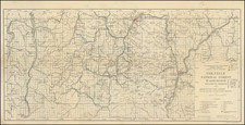
A detailed topographic map of the Seattle Quadrangle, issued by the United States Department of the Interior Geological Survey. This edition, initially released in May 1909 and reprinted in 1942, encapsulates the evolving urban and natural landscapes of Seattle and its surrounding areas at the turn of the 20th century.
The Geological Survey was central to the United States' efforts to document and understand its diverse landscapes. This map of the Seattle Quadrangle, rendered in polyconic projection, is a product of this endeavor. Surveyed using reconnaissance methods in 1893 under the guidance of Geographer A.H. Thompson, the map carries the collaborative efforts of various experts—R.H. McKee's topographic expertise, the Coast and Geodetic Survey's triangulation and coastline data, and the cultural revisions of J.G. Hefty and C.F. Eberly in 1908.
This map offers more than a geographical overview of the Seattle Quadrangle. It presents a historical snapshot of the region, reflecting the changes in human settlement patterns and land use at the beginning of the 20th century. The "culture revised" notation indicates the inclusion of updated anthropogenic features, such as roads, buildings, and other infrastructural elements, providing valuable insights into the region's socio-economic development during this period.
In its intricate detail and historical context, this map stands as a testament to the early cartographic efforts of the United States Geological Survey. It not only charts the physical geography of the Seattle area but also reflects the cultural and societal shifts that shaped this part of the Pacific Northwest during a transformative era in American history.
![[ Pacific Northwest - Northwest Passage ] Limes Occidentis Quivira et Anian. 1597](https://storage.googleapis.com/raremaps/img/small/71207.jpg)