


|
||

|

|
|

|
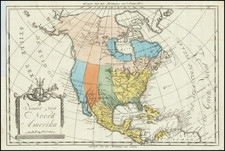
Rare separately published map of North America, published Hocquart in 1833.
The primarly map illustrates the evolving understanding of North America's cartographic features West of the Mississippi River. The boundary shown is drawn from the Adams Onis Treaty of 1819. Texas and Nouvelle California are part of the newly independent Mexico. The Buenaventura River and Miler's River are shown extending from the area around Lake Teguayo (Great Salt Lake) to the Pacific.
In Oregon Territory (District de Columbia on the map), Ft. Astoria is shown, as is Fort D. Dougal (Fort Umpquah), which had just been established at the confluence of Calapooya Creek and the Umpqua River in 1832. A number of other forts (Hudson Bay Company and American) appear further north.
Includes 5 inset maps:
- Russian Alaska and vicinity
- Jamaica
- Cuba, Bahamas and South Florida
- Bahamas and Santa Domingo
- Windward and Leeward Islands
This is the first time we have seen this map.
![[Fruit Crate Label Advertising Map] Panama Brand (North America & Panama Canal)](https://storage.googleapis.com/raremaps/img/small/48860.jpg)
![America [Manuscript Map Showing the Sea of the West!]](https://storage.googleapis.com/raremaps/img/small/41297dm.jpg)