


|
||

|

|
|

|
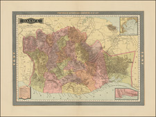
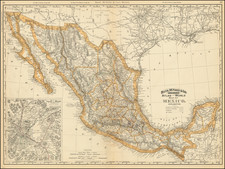
An exceptional example of early 19th-century cartography, this scarce map by Philippe Marie Vandermaelen depicts parts of Texas, New Mexico, and contiguous Mexico, tracing the course of the Rio Grande from Presidio Del Norte to El Paso, Albuquerque, and San Felipe. Published in Brussels in 1825, it stands out as one of the most detailed maps of the region produced up to that time.
The map is part of Vandermaelen's groundbreaking six-volume atlas, which, when combined as globe gores, forms a colossal globe. This monumental work marked the first attempt at mapping the world on a uniform scale, and Vandermaelen's treatment of the Western United States was a landmark in the cartographic history of the region. At a time when American publishers were largely neglecting the area, Vandermaelen undertook the ambitious task of mapping it in 20 sheets. The map features remarkable detail, including at least a dozen place names along the Rio Grande and an informative note on the region. This level of detail and accuracy makes it an essential piece for collectors of Texas and New Mexico cartography.
Vandermaelen's map not only showcases his dedication to cartographic precision but also provides valuable insight into the geography and history of Texas, New Mexico, and Mexico during the early 19th century. This period witnessed significant changes in territorial boundaries and political control, as well as the exploration and settlement of the American West. This map, with its impressive detail and cartographic innovation, captures the essence of this dynamic and transformative era, making it a noteworthy addition to the field of historical cartography.
Philippe Marie Vandermaelen (1795-1869) was a Belgian cartographer and geographer known for his pioneering use of technology and his leadership in establishing the important Establissement geographique de Bruxelles. Born in Brussels, Philippe was obsessed with maps from a young age. He taught himself mathematics, astronomy, and mapmaking and plotted the battles of the Napoleonic wars avidly. He took over his father’s soapmaking business briefly in 1816, but then turned it over to his brother in favor of cartography.
From 1825 to 1827, he released his first atlas, the Atlas universal, which was well received. It was sold in forty installments of ten maps each, with 810 subscribers listed. The atlas contained 387 maps in six volumes at a uniform scale of 1:1.6 million. The maps were intended to be joined and together would create a globe 7.755 meters wide. It was the first atlas to show the entire world on a large uniform scale and was the first atlas produced using lithography. This project served as Vandermaelen’s gateway into intellectual life, gaining him membership in the Royal Academy of Sciences and Belles-Lettres of Brussels (1829).
In 1830, Vandermaelen inherited a laundry from his parents which he converted into the Establissement geographique de Bruxelles, or the Brussels Geographical Establishment. His brother, Jean-Francois, also established a botanical garden on the site. The Establishment had its own lithographic press, one of the first to use the technology for cartography and the first in Belgium. They produced textbooks, surveys, and especially maps of Brussels to be used for urban planning. The complex also housed schools, an ethnographic museum, and a library open to the public. Vandermaelen was passionate about geographic education and saw the Establishment as an open place where people could learn about the world.
In 1836, he was knighted for his services to geography and the intellectual community of Belgium. He died at age 73 in Molenbeek-Saint-Jean, near the Geographical Establishment that he founded. After Vandermaelen’s death, the Geographical Establishment declined, closing its doors in 1880. The extraordinary collection they had amassed passed to several institutions, most importantly the Royal Library of Belgium.
![[Baja California, Gulf of California and Sonora] Amer. Sep. No. 58 Partie De La Vieille Californie](https://storage.googleapis.com/raremaps/img/small/62785.jpg)