|
||

|

|
|

|
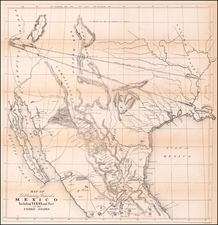
Showing the routes of Andre Fabry and Long's Expedition
Nice example of the first edition of Vandermaelen's exceptional map of Northeastern Texas and Oklahoma, extending from Nacogdoches and the Sabine in the east, including the route of Stephen Long is shown along the Red River, and the route of French Explorer Andre Fabry de la Bruyere across Indian Territory and Texas in 1741 and 1742.
The first edition includes a lithographer's credit and date in the lower right corner, along with Vandermaelen's credit in the lower left corner, both of which are removed in the later edition. While this is the easiest feature identifying the two editions of the map, the plates are in fact completely different engravings.
One of the earliest and most detailed to focus on this region. Shows the Neches River, Rio de la Trinidad ou Arcokisao, Rio Colorado de Texas, Rio Guadalupe (with a Rancho on the Indian Trail), Lac de las Yuntas, Vado de S.Xavier, Rio Florida, Lac Satillo, Monts de San Saba, Rio Brazos de Dios, Petite R. Brazos de Dios, the Presidio (Ft. Houston), Pawnee Villages, a French Canadian Settlement near Jonesboro and Ft. Towson, Ft. Fabry on the Canadian River, established in 1741, Major Long's Route and substantial other detail.
A remarkable map in comparison in terms of scale, at a time when no other map maker was publishing maps of this region. From Vandermaelen's remarkable 6 volume atlas, which if combined as globe gores forms an immense globe. Vandermaelen accomplished the first atlas mapping of the world on a uniform scale. His treatment of the Western US is a landmark in the history the cartography of the Transmississippi West, undertaking to map in 20 sheets a region which American publishers were virtually ignoring.
Andre Fabry de la Bruyere's Searches For A Route To Santa Fe
Following the founding French of Louisiana, the Spanish officials in Spanish Mexico were wary of French activities in the region, as it became apparent expansion of that the French colonial authorities were interested in expanding their influence and trading west toward and into Mexico. Territorial
claims north and west of Red River were poorly defined, and the French began to penetrate the unexplored regions beyond the Mississippi toward Santa Fe, lured by tales of silver.
Andre Fabry de la Bruyere was among those who strove to reach Santa Fe. He was a French naval officer charged by the Louisiana governor to follow the Canadian River from Arkansas Post west ward toward Santa Fe in the hope that he would discover a route and possibly initiate trade with the Spanish.
In 1741, Andre Fabry de la Bruyere led an expedition from New Orleans in search of a route to Santa Fe, then the capital of Spanish Mexico. The French government had a keen interest in establishing trade relations with the Spanish colonies in Mexico, and Fabry de la Bruyere's journey was seen as a crucial step in achieving that goal.
The expedition consisted of a small group of French soldiers and traders, as well as a number of Native American guides and interpreters. They traveled up the Red River and into present-day Oklahoma, following a route that had been established by earlier French explorers. The expedition reached the Pecos River in present-day New Mexico, but was unable to continue on to Santa Fe due to the presence of Spanish authorities, who were suspicious of the French presence in the region. Along the way, Fabry's party established two forts which were occupied for a period of time, before being abandoned in 1742.
Fabry de la Bruyere's journey was one of the first attempts by the French to penetrate deep into the interior western regions of North America and establish trade relations with the Spanish colonies. The journey also provided valuable information about the geography and resources of the region, which would be useful for future explorers and traders.
Philippe Marie Vandermaelen (1795-1869) was a Belgian cartographer and geographer known for his pioneering use of technology and his leadership in establishing the important Establissement geographique de Bruxelles. Born in Brussels, Philippe was obsessed with maps from a young age. He taught himself mathematics, astronomy, and mapmaking and plotted the battles of the Napoleonic wars avidly. He took over his father’s soapmaking business briefly in 1816, but then turned it over to his brother in favor of cartography.
From 1825 to 1827, he released his first atlas, the Atlas universal, which was well received. It was sold in forty installments of ten maps each, with 810 subscribers listed. The atlas contained 387 maps in six volumes at a uniform scale of 1:1.6 million. The maps were intended to be joined and together would create a globe 7.755 meters wide. It was the first atlas to show the entire world on a large uniform scale and was the first atlas produced using lithography. This project served as Vandermaelen’s gateway into intellectual life, gaining him membership in the Royal Academy of Sciences and Belles-Lettres of Brussels (1829).
In 1830, Vandermaelen inherited a laundry from his parents which he converted into the Establissement geographique de Bruxelles, or the Brussels Geographical Establishment. His brother, Jean-Francois, also established a botanical garden on the site. The Establishment had its own lithographic press, one of the first to use the technology for cartography and the first in Belgium. They produced textbooks, surveys, and especially maps of Brussels to be used for urban planning. The complex also housed schools, an ethnographic museum, and a library open to the public. Vandermaelen was passionate about geographic education and saw the Establishment as an open place where people could learn about the world.
In 1836, he was knighted for his services to geography and the intellectual community of Belgium. He died at age 73 in Molenbeek-Saint-Jean, near the Geographical Establishment that he founded. After Vandermaelen’s death, the Geographical Establishment declined, closing its doors in 1880. The extraordinary collection they had amassed passed to several institutions, most importantly the Royal Library of Belgium.