|
||

|

|
|

|
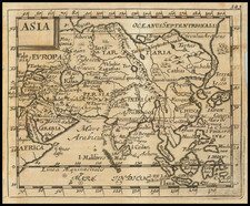
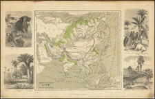
Third state (of 3) of this rare English John Overton map of Asia, based on Visscher's carte-a-figures map of the continent.
The map was first published in 1668, with three recorded plate changes, the last of which was done circa 1675.
Covering nearly the entirety of Asia, this map encompasses regions such as the Arabian Peninsula, Southeast Asia, Japan, Korea, China, Tartary, and India. The expansive scope of the map provides a comprehensive representation of Asia's geography, political divisions, and urban centers during the 17th century.
This remarkable carte-a-figures map of Asia features an array of captivating vignettes that enhance its visual appeal and historical significance. The vignettes, which depict cities, kingdoms, and people from various regions, provide unique insights into the cultural diversity and geographic characteristics of 17th-century Asia.
The top row of vignettes illustrates the following cities and kingdoms:
- Aden
- King of Tartaria
- Jerusalem
- Goa
- Macao
- King of China
- Rhodes
At the bottom the vignettes are as follows:
- Arosbay
- King of Ceylon (present-day Sri Lanka)
- Calicut
- King of Persia
- Hormuz (Ormus)
- King of Turkey
- Banten
- King of Molucca (Maluku Islands)
- Gamalama
The left side features illustrations of individuals representing different cultures and regions, including:
- A Tartarian woman
- A Chinese (Chinean) person
- An Arabian woman
- A Javan (from Java, Indonesia)
On the right side, the map presents additional cultural representations:
- A Tartarian
- A Chinese (Chinean) woman
- An Arabian
- A Javan woman
These detailed and artistic vignettes serve to enrich the map's overall presentation, showcasing the diversity of Asia's inhabitants and offering glimpses into the architecture and urban landscapes of the period. As a result, this carte-a-figures map stands as an invaluable resource for understanding the cultural, historical, and geographical aspects of 17th-century Asia.
The Overton family was a prominent part of the printing, and mapmaking, industry in London in the seventeenth and eighteenth centuries. John Overton (1639/40-1713) was the son of a tailor who apprenticed to Stationer Thomas Gould. He was made free of the Stationers’ Company in 1663. Two years later, London was struck by the Great Plague of 1665-6. Peter Stent, a leading printseller, succumbed and Overton took over his shop. This burned in the Great Fire of 1666, but Overton had rebuilt by 1669, when he advertised his wares from the White Horse on Snow Hill. Overton specialized in prints, portraits, and especially maps and topographical views.
John was likely married three times and had seven children. His eldest, Thomas, emigrated to America. His second oldest, Henry, was executor of John’s will when the latter died in 1713. Henry (1675/6-1751) acquired his father’s stock in 1707 and ran the shop until his own death in 1751. He published many maps, most focusing on the British Isles. His shop and stock passed to his nephew, another Henry, son of John’s fourth son, James.
Henry the Elder’s brother, Philip (ca. 1681-1745), was also a printer and mapmaker. Philip served as his father’s apprentice and was made free of the Stationers’ in 1702. His father set him up in the trade in 1707 and by 1710 he was working from the sign of the Golden Buck in Fleet Street. Philip specialized in fine arts prints, including Hogarth’s Hudibras set (1726), but he also sold many maps. At his death in 1745 he left his shop to his widow, Mary. She ran the shop and then married James Sayer, whose brother, Robert, became Mary’s assistant. He took over the business in 1748 and became a famous purveyor of maps, charts, and views.
Back at the sign of the White Horse, Henry the Younger continued the family business, expanding their stock to include a large collection of landscape views. He often partnered with Robert Sayer. He continued in business until at least 1764, when he drops out of the historical record.
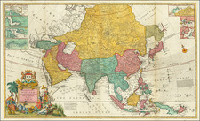
![Asia Cum Omnibus Imperiis Provinciis Statibus et Insulis Iuxta Observationes Recentissimas et Accuratissimas… [Asia, with all the empires, provinces, states, and islands, according to the most recent and accurate observations...]](https://storage.googleapis.com/raremaps/img/small/95548.jpg)