|
||

|

|
|

|
An impressive 1749 map of ancient ecclesiastical provinces and bishoprics in Spain during the Gothic period, titled Mapa de los Obispados y Provincias antiguas de la Iglesia de España en tiempo de los Godos, delineated by Enrique Flórez and engraved by José Andrade.
This remarkable map, published in Madrid by Antonio Marín, provides a detailed visualization of Spain's ecclesiastical landscape during the Gothic period, featuring ancient provinces and bishoprics. The map showcases the various ecclesiastical seats that persisted from the Roman era into the Gothic period, offering valuable historical context on the continuity and development of religious institutions in Spain.
Topographical features are depicted with profiled mountains, while Latin and Castilian toponyms, hydrography, and conventional signs for cities further enhance the map's detail. The title cartouche is adorned with two columns supported by inscriptions of Saint Paul and Saint James, alongside the anagram IHS and the cross of the Order of Santiago over a scallop shell.
Mapa de los Obispados y Provincias antiguas de la Iglesia de España en tiempo de los Godos was included in the first edition of Volume 4 of Enrique Flórez's La España Sagrada, a seminal work in the study of ecclesiastical history and geography in Spain. This map stands as a significant contribution to the understanding of Spain's religious history and offers an engaging and informative addition to any collection of antique maps or materials related to the history of Spain and its ecclesiastical institutions.
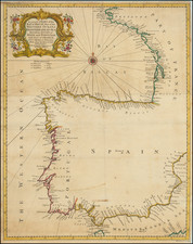
![[ Galicia ] Die Zee Custen van Galissien, van Capo Daviles off tot Ortegal . . .](https://storage.googleapis.com/raremaps/img/small/39921.jpg)
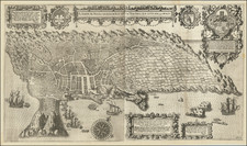
![[Lisbon]](https://storage.googleapis.com/raremaps/img/small/93274.jpg)
![[Azores] Carta Reducida y General de Las Islas de los Azores . . . 1781 [east sheet]](https://storage.googleapis.com/raremaps/img/small/93245.jpg)