|
||

|

|
|

|
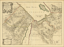
A rare Czech language edition of Bunting's Itinerarium Sacrae Scripturae, first published in 1581, presents a captivating view of the Eastern Mediterranean, featuring Sicily, Malta, Cyprus, Rome, the Holy Land, Alexandria, the southern Black Sea, Constantinople, Greece, Asia Minor, Armenia, and more, alongside a sea monster in the Mediterranean.
Heinrich Bunting, a German Protestant pastor and theologian, created this map as part of his Itinerarium Sacrae Scripturae, which sought to depict the geographical settings of biblical narratives. As a work of cartography and religious scholarship, Bunting's map not only provides an insight into the geographical understanding of the Eastern Mediterranean in the late 16th century but also offers a window into the religious climate and biblical interpretations of the time.
This particular edition, issued in Prague in 1592, stands out for its rich, dark impression of the map and the accompanying Czech text on the verso. The Czech language edition highlights the spread of Bunting's work beyond the German-speaking world and emphasizes the importance of religious texts and cartography in the cultural and intellectual exchange between regions during the early modern period.
The Itinerarium Sacrae Scripturae by Heinrich Bunting is a significant work that combines the realms of cartography and theology, reflecting the intellectual and religious milieu of the late 16th century. Its rarity and historical value make it a noteworthy addition to any collection of antiquarian maps and religious texts.
Henrich Bunting was a Protestant theologian and teacher born in Hanover, in what is now Germany. He attended the University of Wittenberg and graduated in 1569. He then began work as a preacher but caused some controversy with his teachings; he was dismissed from appointments in both Lemgo and Goslar.
He is best known today for his book, Itinerarium Sacrae Scripturae (Travel book through Holy Scripture), a travel collection and commentary of the geography of the Bible. The book provided the most complete summary of biblical geography then available and described the Holy Land by following the travels of various notable people from the Old and New Testaments. First published in Madgeburg in 1581, Itinerarium Sacrae Scripturae was a very popular book for the time. Over 60 editions were published between 1581 and 1757.
A particularly notable feature of the book were its many woodcut maps, many of them showing unique depictions of geographic features and continents. In addition to the conventional maps, the book also contained three figurative maps; the world depicted using a cloverleaf design (thought to possibly represent the Trinity with Jerusalem in the center), Europe in the form of a crowned and robed woman, and Asia as the winged horse Pegasus.

![[ Mount of Olives ] Afbeelding Van Den Olyfberg. Volgens de hedendaagsche Reizigers](https://storage.googleapis.com/raremaps/img/small/101645.jpg)