|
||

|

|
|

|
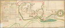
Titled Mediolanum vulgo Milano (Mediolanum, commonly known as Milan), this bird's-eye view map of Milan, Italy, published by Pierre Mortier in Amsterdam in 1704, presents the city's architectural, military, and topographical features, capturing an extraordinary 256 locations, all pinpointed and indexed. The map is further enhanced by the inclusion of the coats of arms representing the King of Spain and Milan, emphasizing their historical affiliation.
The map's origin in Blaeu's town book of Italy in 1663 situates it within a crucial period of Milan's history. At this time, Milan was under Spanish rule, part of the vast Habsburg empire that left a lasting impact on the city's culture, governance, and fortifications. The coats of arms included on the map symbolize this connection.
The level of detail and precision with which the city is rendered in the view speaks to an era of growing interest in urban planning, architecture, and military engineering. Milan's fortifications, streets, and surrounding rural landscape are depicted with remarkable care, allowing for an understanding of the city's strategic layout and its integration with the surrounding territory. The extensive key, indexing 256 locations, further underscores the map's utility as a reference document.
In addition to its historical significance, Mediolanum vulgo Milano offers insights into the artistic and cartographic practices of the early 18th century. The republishing of the map by Pierre Mortier in 1704 and 1705 attests to its lasting value and the continuous interest in accurate and visually engaging representations of urban spaces. The map's blend of visual detail, historical context, and cartographic precision contributes to its enduring importance as an artifact of Milan's complex history and urban development.
Pierre, or Pieter, Mortier (1661-1711) was a Dutch engraver, son of a French refugee. He was born in Leiden. In 1690 he was granted a privilege to publish French maps in Dutch lands. In 1693 he released the first and accompanying volume of the Neptune Francois. The third followed in 1700. His son, Cornelis (1699-1783), would partner with Johannes Covens I, creating one of the most important map publishing companies of the eighteenth century.
![[ Lucca, Tuscany ] Luca](https://storage.googleapis.com/raremaps/img/small/71022.jpg)
![[ Villa Farnese ] Caprarola Arx et Horti Farnesiani](https://storage.googleapis.com/raremaps/img/small/96849.jpg)