|
||

|

|
|

|
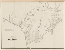
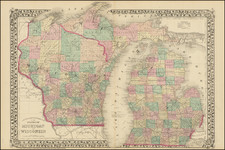
This 1881 promotional broadside map, titled "Wisconsin Central Railroad Lands," showcases the vast acreage of timber and farming lands available for sale along the Wisconsin Central Railroad. The lands stretch from Marquette County in central Wisconsin, north and west towards Lake Superior. The text at the top and bottom of the map highlights the richness and diversity of the landscape, mentioning the various types of timber and the excellent soil quality, making it ideal for agriculture and dairy farming.
The map outlines the grant limits of the Wisconsin Central Railroad and the locations of the available lands, emphasizing the benefits of the region's water and healthy climate. The absence of fever, ague, grasshoppers, and tornadoes in Wisconsin is highlighted, appealing to those seeking a safer and more productive environment for their families and businesses. The demand for labor in the area, both in the woods and at the saw-mills, is also mentioned, offering opportunities for employment to new settlers.
The land for sale ranges in price from $2.50 to $6.00 per acre, depending on quality and location, with the terms of purchase described as reasonable. The text encourages interested parties to contact Charles L. Colby for more information about the lands, as well as for a pamphlet containing full particulars. Land exploring tickets are offered at reasonable rates, with the money paid for them refunded to the purchasers of the lands.
As a historical artifact, this broadside map provides valuable insights into the marketing strategies used by the Wisconsin Central Railroad to promote land sales and settlement along its rail line.