


|
||

|

|
|

|
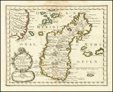
This 1702 map by Johann Ulrich Muller is a fascinating representation of the Cape Verde Islands, an archipelago located off the northwest coast of Africa. The map is subtitled "Die Jufuln deß grünen Bors Gebürges seyn," which translates to "The Islands of the Green Cape Mountains." It provides a detailed view of the ten main islands in the Cape Verde chain. The islands are individually labeled, showcasing their distinct features and coastlines.
The primary islands depicted on the map are:
- S. Jago (Santiago)
- S. Antonio (Santo Antão)
- S.Vincent (São Vicente)
- S. Lucia (Santa Luzia)
- S. Nicolao (São Nicolau)
- Del Sal (Sal)
- Bona Viſta (Boa Vista)
- Majo (Maio)
- Fuogo (Fogo)
- Brava
Each island is numbered and labeled with its corresponding name. Additionally, the map includes notable features such as coastal cities, capes, and various bodies of water in the surrounding area. The geographical information provided by Muller gives a comprehensive and insightful view of the Cape Verde Islands in the 18th century.
![XV. b [Cape Verde]](https://storage.googleapis.com/raremaps/img/small/93302.jpg)
![[T erceira ] Circuito da Ilha Terceira, dividido em 8 Districtos Militares, forca de cada um, e os lugares accessi veis, os quars sao indicados com o signal, *' assim as pecas com a letra p](https://storage.googleapis.com/raremaps/img/small/77790.jpg)
![[Palma, Tenerife, Gomera, Hierro] Isla Canarias 1a. Hoja](https://storage.googleapis.com/raremaps/img/small/79081.jpg)