|
||

|

|
|

|
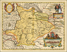
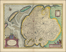
A fine representation of early 17th-century cartography, this small map of northern Holland by Petrus Bertius captures the intricate geography of the region, with particular focus on the Zuyder Zee, and features Amsterdam prominently at the bottom center.
Petrus Bertius, a Dutch cartographer and theologian, was known for his production of miniature maps that offered remarkable detail and accuracy despite their small size. This map is taken from his work "Tabularum Geographicarum Contractarum," a collection of maps that showcased the varied landscapes of Europe and other continents. The map's letterpress title at the top reads "Description de la Hollande Septentrionale en la Gaule Belg.," highlighting the focus on the northern region of Holland within the Belgian Gaul.
During the 17th century, the Dutch Republic was experiencing a period known as the Dutch Golden Age, marked by significant advancements in trade, science, and the arts. Amsterdam, in particular, was rapidly growing into a major trading and financial center. This map, while highlighting the geography of northern Holland, also serves as a visual testament to the burgeoning importance of the region during this period.
Petrus Bertius was a Flemish historian, theologian, geographer, and cartographer. Known in Dutch as Peter de Bert, Bertius was born in Beveren. His father was a Protestant preacher and his family fled to London around 1568. The young Bertius only returned to the Low Countries in 1577, to attend the University of Leiden. A bright pupil, Bertius worked as a tutor and was named subregent of the Leiden Statencollege in 1593. He ascended to the position of regent in 1606, upon the death of the former regent, who was also Bertius’ father-in-law. However, due to his radical religious views, he eventually lost his teaching position and was forbidden from offering private lessons.
His brothers-in-law were Jodocus Hondius and Pieter van den Keere, who were both prominent cartographers. Bertius began his own cartographic publishing in 1600 when he released a Latin edition of Barent Langenes’ miniature atlas Caert Thresoor (1598). He published another miniature atlas that first appeared in 1616.
By 1618, Bertius was named cosmographer to Louis XIII. He converted to Catholicism and took up a position as professor of rhetoric at the Collège de Boncourt (University of Paris). In 1622, Louis XIII created a chart of mathematics specifically for Bertius and named him his royal historian. He died in Paris in 1629.