|
||

|

|
|

|
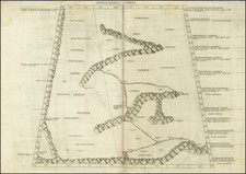
"China" is a meticulously detailed map by Thomas Jefferys, published in London in 1754. It provides an intricate representation of China, Korea, and parts of Tibet, showcasing provinces, cities, rivers, lakes, mountains, islands, and other geographical features.
Constructed in the mid-18th century, this map is grounded in the era's emerging cartographic and geographical understanding. During this period, European exploration and trade in the East were expanding, leading to an increased demand for reliable maps of Asia. Thomas Jefferys, Geographer to King George III, was renowned for his comprehensive and accurate maps, and this example is no exception. It offers a fascinating glimpse into the geographical knowledge of the time, marking an important stage in the history of cartography.
The breadth of coverage in this map is remarkable. It stretches westward to Lake Puka, or Terkiri, in Tibet, and prominently features the Cobi or Sandy Desert, known as Shamo by the Chinese. The territories of the Mongos and Kalas, along with the Kingdoms of Yawaka or Ava, Myenki or Pegu, Laushau or Lauo, and Tonquin, are also depicted, reflecting the political geography of the period.
Accompanying the mainland, the map also illustrates several place names on Taiwan and the Hayanan Islands. These insular features provide an interesting counterpoint to the mainland, highlighting the vast maritime expanse surrounding China's coastlines.
In its totality, this map is a charming representation of 18th-century English cartography. The precision and complexity of its depiction of China and its surrounding regions make it a significant historical document, reflecting the expanding horizons of European geographical knowledge during this period.
Thomas Jefferys (ca. 1719-1771) was a prolific map publisher, engraver, and cartographer based in London. His father was a cutler, but Jefferys was apprenticed to Emanuel Bowen, a prominent mapmaker and engraver. He was made free of the Merchant Taylors’ Company in 1744, although two earlier maps bearing his name have been identified.
Jefferys had several collaborators and partners throughout his career. His first atlas, The Small English Atlas, was published with Thomas Kitchin in 1748-9. Later, he worked with Robert Sayer on A General Topography of North America (1768); Sayer also published posthumous collections with Jefferys' contributions including The American Atlas, The North-American Pilot, and The West-India Atlas.
Jefferys was the Geographer to Frederick Prince of Wales and, from 1760, to King George III. Thanks especially to opportunities offered by the Seven Years' War, he is best known today for his maps of North America, and for his central place in the map trade—he not only sold maps commercially, but also imported the latest materials and had ties to several government bodies for whom he produced materials.
Upon his death in 1771, his workshop passed to his partner, William Faden, and his son, Thomas Jr. However, Jefferys had gone bankrupt in 1766 and some of his plates were bought by Robert Sayer (see above). Sayer, who had partnered in the past with Philip Overton (d. 1751), specialized in (re)publishing maps. In 1770, he partnered with John Bennett and many Jefferys maps were republished by the duo.