|
||

|

|
|

|
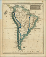
Jacques Chiquet's "LAmerique Meridionale..." from 1719 is a finely engraved map of South America. Featured in Chiquet's scarce "Le Nouveau et Curieux…", it is marked by a unusual vignette depicting a naval battle between native and European vessels.
At the time of this map's creation, Europe was in the throes of the Age of Enlightenment, an era characterized by a fervent pursuit of knowledge. The exploration of new lands and the resulting cartographic advancements were a significant part of this intellectual fervor. Chiquet's map of South America offers a snapshot of the geographical understanding of the continent during this period, with detailed depictions of rivers, towns, and lakes, which encapsulates the era's focus on precision and detail.
The map further includes a note at the bottom describing Magellan's discovery of the Straits of Magellan in 1520 during his circumnavigation aboard the Victoria. This inclusion serves as a testament to the transformative voyages of exploration that reshaped the world's geographical understanding and set the stage for the map-making advancements of the Enlightenment.
Chiquet's "L'Amerique Meridionale qui fait l'autre partie des Indes Occidentales..." is an attractive map that combines the precision of Enlightenment cartography with intricate artistic elements. Its rich detailing and historical annotations offer valuable insights into South America's geographical understanding in the early 18th century.
![The Coast of Newfoundland From Plancentia to Cape Bonavista [and] A Draught of the River Plata in South America [and] Havana, Harbour [and] the Bay of Honda](https://storage.googleapis.com/raremaps/img/small/38599.jpg)
![(Malaspina Expedition): [Group of six manuscript documents, signed, related to a future assignment for the officers of the Malaspina expedition, including a voyage to chart the coast of Guatemala and to explore Nicaragua, proposed by the viceroy of New Spain]](https://storage.googleapis.com/raremaps/img/small/101838.jpg)