


|
||

|

|
|

|
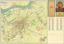
Frankfurt Am Main Rarity
Finely engraved and very rare early 18th Century plan of Frankfurt, Christian Ludwig Thomas, Hessen-Darmstadt geographer and surveyor, draftsman and author.
This map, titled "Neuer Plan der Romisch Kayserlichen freyer Reichs, Wahl und Handelstadt Franckfurth am Mayn" (New Plan of the Roman Imperial Free Electoral and Trading City of Frankfurt am Main), is a detailed map of Frankfurt am Main from the year 1783.
The map showcases the city's layout, streets, and significant landmarks, and is accompanied by a detailed introduction and two unusual prospect views of the city from the southeast and southwest.
The introduction (in German) highlights the historical importance of Frankfurt, mentioning its role as the city where the election of the Roman Emperors took place, as per the Golden Bull. It also mentions that Frankfurt is the meeting place for representatives of the Upper and Electoral Rhenish Circle, and one of the four most important trade cities in Germany. The city lies along the beautiful and fertile banks of the River Main, which divides it into two parts: Franckfiath and Sachsenhausen. The city's coat of arms features a white eagle on a red field.
The map also mentions various aspects of Frankfurt's urban life and trade, including the famous fairs held twice a year, which attract visitors from all over Europe. It highlights the well-maintained roads, mulberry trees planted for silkworm cultivation, nighttime illumination of the entire city, protection for arts and sciences, public safety, continuous beautification efforts, and flourishing trade as testimonies to the wise governance of the city's administration.
There are two city views included on the map:
- Lower left corner: "Prospect der Stadt Hranickitirih või der Strd West Seife!" (View of the City of Frankfurt from the Southwest Side)
- Lower right corner: "Prospect der Stade Franckfurth von der Sud Ost Seite" (View of the City of Frankfurt from the Southeast Side)
In the bottom center, there is a dedication box, which dedicates the map to the noble and wise administration of Frankfurt. The dedication is signed by Christian Ludung Thomas, who refers to himself as a humble and obedient servant of the administration. This is one of at least two detailed plans of Frankfurt prepared by Thomas, who also published Geometrischer Plan von der Gegend der Freyen Reichs Wahl und Handel Stadt Franckfurth am Mayn in 1790.
The imprint line in the lower right corner below the neatline indicates that the map can be found at Heinrich Ludwig Brönner's store near the parish.
Rarity
The map is apparently very rare on the market.
Other than German institutional collections, OCLC locates on 1 example (British Library).
![[ Rhine, Waal & Meuse / Maas Rivers ] Tractus Rheni et Mosae totusque Vahalis à Rhenoberca Gorcomium usque cum turris adjacentibus ducatus Cliviae regno Noviomagensi et Bommelerwaer . . .](https://storage.googleapis.com/raremaps/img/small/99171.jpg)
![(First state!) [ Rhine River Valley ] Quarta Rheni et IX Nova Tabula](https://storage.googleapis.com/raremaps/img/small/95910.jpg)

![(Hessen) Carte Tres Detaillee de la Partie Meridionale du Landgraviat de Hesse-Cassel Ainsi que de la Partie Meridionale de la Vetteravie, et de Plusieurs Autres Pays Adjacents [Detailed Map of the Southern Part of the Landgraviat of Hesse-Cassel. . .]](https://storage.googleapis.com/raremaps/img/small/88742.jpg)