


|
||

|

|
|

|
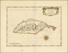
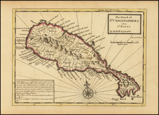
Rare early map of St. Christopher of St. Kitts, published in Paris at an important early moment in its French colonial history.
Oriented with northeast at the top, tthe map illustrates the mountainous terrain of the island, a silver mine and sulphur mine, several anchorages, a Jesuit Mission, Fort Basse Terre, Fort Louis, 3 unnnamed forts, Nostre Dame, and the house of Mr. de Poincy are shown. Phillippe de Longvilliers de Poincy (1584–1660) was a French nobleman and Bailiff Grand Cross of the Knights of Malta. He governed the island of Saint Christopher from 1639 to his death in 1660, first under the Compagnie des Îles de l'Amérique and later under the Knights of Malta themselves. Poincy was the key figure in the Hospitaller colonization of the Americas.
Created by François de La Pointe and published by Thomas Jolly in 1667, the map offers a valuable insight into the historical context of St. Kitts and its connection to French colonial ambitions in the West Indies. Its representation in Jean Baptiste Du Tertre's "Histoire generale des Antilles habitées par les Francois ... " underscores the importance of the French presence in the region.
Includes 3 coats of arms and medallions.
Du Tertre was sent by the Dominicans as a missionary to the Antilles, where he stayed from 1640 until 1658. His book was described by Sabin as "One of the most valuable [works] we possess on the West Indies." The work is scarce, the final volume, issued in 1671 with additional maps, is very quite rare.
Coronelli copied this map in the 1680s and early 1690s.
Rarity
This is the first time we have offered this map for sale.
![Guadaloupe [with] Antigua [with] Mariegalante &c.](https://storage.googleapis.com/raremaps/img/small/72024.jpg)

![[Turks & Caicos, Bahamas, Hispaniola and Cuba]. Carte Reduite Des Debouquements, De St. Domingue, Levee, Dressee et Publiee par Ordre du Roi . . . 1787](https://storage.googleapis.com/raremaps/img/small/83475.jpg)