|
||

|

|
|

|
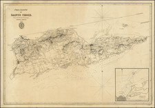
Rare early map of St. Croix, published in Paris at an important early moment in its French colonial history.
The French first attempted to colonize St. Croix in 1651. Of 300 colonists, two thirds and two governors died of illness during the first year. Ten years later the Governor of St. Kitts, De Poincy, bought St. Croix as his private estate and later deeded it to the Knights of Malta. The Order fared poorly and in general were considered to be rich young aristocrats who knew little about colonization. In 1665, the French West Indian Company bought the island from the Knights.
Within a short time, under the leadership of Governor Francois DuBois, the island had 90 plantations. Crops included tobacco, cotton, sugar cane and indigo.
The island is meticulously charted, with careful attention to detail - each geographical feature is vividly etched. The map portrays the vibrant life of the island, its settlements, and the varied landscape of hills, forests, and coastlines. The scale of the map balances an overall view of the island with detail sufficient to distinguish key geographical features and human settlements.
In the inset, a more detailed plan and profile of the Governor's mansion (castle) and grounds provide a fascinating snapshot of colonial architecture and layout. The depiction of the mansion, presumably Monsieur du Bois' residence, hints at the European lifestyle transported to this Caribbean setting. The grounds are meticulously laid out, showcasing formal gardens, lanes, and outbuildings, suggesting an ordered and opulent lifestyle. An intriguing question that continues to pique curiosity in modern times is the location of the "castle" of the French Governor du Bois, who presided from 1659 until 1671. This map seemingly answers the question.
Created by François de La Pointe and published by Thomas Jolly in 1667, the map offers a valuable insight into the historical context of St. Croix and its connection to French colonial ambitions in the West Indies. The island was governed by Mr. de Parquet at the time, and its representation in Jean Baptiste Du Tertre's "Histoire generale des Antilles habitées par les Francois ... " underscores the importance of the French presence in the region.
Du Tertre was sent by the Dominicans as a missionary to the Antilles, where he stayed from 1640 until 1658. His book was described by Sabin as "One of the most valuable [works] we possess on the West Indies." The work is scarce, the final volume, issued in 1671 with additional maps, is very quite rare.
Coronelli copied this map in the 1680s and early 1690s.
Rarity
This is the first time we have offered this map for sale.
![[Heighted with Gold] Pascaert Vande Caribes Eylanden](https://storage.googleapis.com/raremaps/img/small/91150.jpg)
![[ Virgin Islands, etc ] Supplément pour les Isles Antilles, extrait des cartes Angloises](https://storage.googleapis.com/raremaps/img/small/98774.jpg)