|
||

|

|
|

|
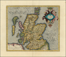
Striking full color example of Mercator's map of Scotland.
Gerard Mercator's map of Scotlan is an important cartographic work that provides a fascinating glimpse into Scotland's geography during the late 16th and early 17th centuries. The map is part of a larger atlas called "Atlas sive Cosmographicae Meditationes de Fabrica Mundi et Fabricati Figura," which was first published by Mercator's son, Rumold Mercator, after Gerard's death in 1594.
The map is richly decorated with ornate lettering and a decorative strapwork cartouche.
The main body of the map depicts Scotland's topography in impressive detail, with mountains, rivers, and cities clearly marked and labeled. The map also includes important features such as islands, bays, and estuaries, as well as the surrounding seas.
The map is a beautiful and historically significant work of cartography that offers valuable insights into Scotland's geography and culture during the early modern period.
Gerard Mercator is one of the most famous cartographers of all time. Mercator was born in Flanders and educated at the Catholic University in Leuven. After his graduation in 1532, Mercator worked with Gemma Frisius, a prominent mathematician, and Gaspar a Myrica, a goldsmith and engraver. Together, these men produced globes and scientific instruments, allowing Mercator to hone his skills.
With his wife, Barbara, Mercator had six children: Arnold, Emerentia, Dorothes, Bartholomeus, Rumold, and Catharina. In 1552, Mercator moved to Duisburg from Leuven, where he lived for the rest of his life. In 1564, he was appointed the official cosmographer to the court of Duke Wilhelm of Cleve.
Mercator’s most important contribution was the creation and popularization of a projection which now bears his name. On Mercator projection maps, all parallels and meridians are drawn at right angles to each other, with the distance between the parallels extending towards the poles. This allowed for accurate latitude and longitude calculation and also allowed navigational routes to be drawn using straight lines, a huge advantage for sailors as this allowed them to plot courses without constant recourse to adjusting compass readings.
Mercator’s other enduring contribution to cartography is the term “atlas”, which was first used to describe his collection of maps gathered in one volume. The Mercator atlas was published in 1595, a year after Mercator’s death, thanks to the work of his sons, particularly Rumold, and his grandsons.
![[Hungarian Map of Great Britain] Nagy Britannia](https://storage.googleapis.com/raremaps/img/small/85219.jpg)
![[Scotland] Scotiae Tabula](https://storage.googleapis.com/raremaps/img/small/35612.jpg)