


|
||

|

|
|

|
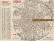
Scarce map of "Great Los Angeles," illustrating the Freeway and Highway System in the region as of 1965.
Brewster's wall map presents a clean and well defined depiction of the region at the height of the freeway construction boom in the mid-1960s, at a time when gasoline was cheap, Detroit was King of the Automobile Industry and the First OPEC Oil Embargo was still nearly a decade away.
The map locates:
- Existing Freeways and Freeways under construction (red)
- Adopted future Freeways (red dots)
- Major Highways (thick black line)
- Secondary Highways (thin black line)
The map also differentiates between Interstate routes, US Highway Route and State Highway Routes. Concentric circles radiate out from
The Master Plan of Metropolitan Los Angeles Freeways was adopted by the Regional Planning Commission in 1947 and construction began in the early 1950s. The plan began to face meaningful opposition and funding limitations in the 1970s, and by 2004, only some 61% of the original planned network had been completed.
Southern California's automobile boom began in part as a backlash against the Southern Pacific Railroad's tight control over the region's commerce in the late 19th and early 20th centuries. In the early 20th Century, automobile travel offered liberation and was the favorite of progressive government, juxtaposed against the railroads' control over the corrupt governments of the Midwest and Northeast.
The Southern Pacific-owned Pacific Electric Railway's Red Car streetcar lines were largely unable to profitably keep up with the rapid growth of the 1910s and 1920s. By contrast, the automobile made the vast underdeveloped regions of Greater Los Angeles reachable by a road. As cars became cheaper and began to fill the region's roads in the 1920s, Pacific Electric lost ridership. Traffic congestion soon threatened to choke off the region's development altogether. Urban planners pushed construction of a road network to support suburban development. These "greenbelt" advocates called for decentralized, automobile-oriented development as a means of remedying both urban overcrowding and declining rates of home ownership.
By the 1930s, traffic congestion became a serious issue in the Los Angeles metropolitan area. The politically powerful Automobile Club of Southern California engineered an elaborate plan to create an elevated freeway-type "Motorway System," a key aspect of which was the dismantling of the streetcar lines, to be replaced with buses that could run on both local streets and on the new express roads. In the late 1930s, when the freeway system was originally planned locally by Los Angeles city planners, they had intended for light rail tracks to have been installed in the center margin of each freeway (which would presumably have carried Pacific Electric Railway red cars), but this plan was never fully implemented.
By World War II, congested Southern California roads and railways made it imperative that for continued growth, Los Angeles needed a completely new transportation system. While the city of Los Angeles favored an upgraded rail transit system, the success of the Arroyo Seco Parkway, built between Los Angeles and Pasadena in 1940, was seen as evidence that a freeway system could solve the region's transportation problems.
Surrounding cities, such as Whittier, South Gate, Long Beach, and Pasadena, called for a web of freeways to connect the whole region, rather than a system with downtown Los Angeles as a hub. By 1947, a new comprehensive freeway plan for Los Angeles (based largely on the original locally planned 1930s system) was proposed by the California Department of Public Works (now Caltrans) and the era of Southern California freeways as launched.
Rarity
The map is very rare, with no auction records and no examples illustrated or otherwise described on line.
OCLC locates 4 examples in University of California libraries, but we suspect these are digital records. OCLC notes an earlier edition of the map, issued in 1961, for which there are 2 copies (UCLA and University of Illinois).
![[ La Puente ] Geological Survey Los Angeles County Puente Quadrangle](https://storage.googleapis.com/raremaps/img/small/82489.jpg)

![[Hollywood / Los Angeles] Castle's Inc. Hollywood's Complete Camera Store](https://storage.googleapis.com/raremaps/img/small/73017.jpg)