|
||

|

|
|

|
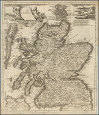
A rare and finely detailed map of Scotland from 1760, created by Robert Sayer, Carington Bowles, and John Bowles, "A Map of North Britain or Scotland from the Newest Surveys & Observations" offers a comprehensive view of the country, complete with a large inset of the Shetland Islands, and featuring color-coded counties.
This meticulously crafted map provides an abundance of information, locating parliamentary boroughs, significant towns, kirks, castles, roads, and other important details. The parliamentary boroughs are distinguished by Roman lettering, such as Kintore, while other notable places are marked by a special character. The map also includes an explanation key that aids the reader in understanding the various symbols and designations used throughout the map.
At the time this map was produced, Scotland was undergoing significant cultural, social, and economic changes as part of the larger transformation of the British Isles. The map serves as an important historical record of the country's geography, political divisions, and infrastructures during this period. The precision and richness of the map's details are a testament to the skill and dedication of its creators, who sought to provide an accurate and informative representation of the region.
As a remarkable example of 18th-century cartography, this scarce map of Scotland holds both artistic and historical significance. Its inclusion of a wide range of geographical features and locations, as well as its striking visual presentation, make it a valuable resource for those interested in the history and development of Scotland during a pivotal era in its evolution.
Robert Sayer (ca. 1724-1794) was a prominent London map publisher. Robert’s father was a lawyer, but his older brother married Mary Overton, the widow of prominent mapmaker Philip Overton and the proprietor of his shop after his death. Mary continued the business for roughly a year after her marriage and then, in early 1748, it passed to Robert. Robert became a freeman of the Stationers’ Company later that year; his first advertisement as an independent publisher was released in December.
Sayer benefited from Overton’s considerable stock, which included the plates of John Senex. In the 1750s, Sayer specialized in design books and topographical prints, as well as comic mezzotints. In 1753, he, along with John Roque, published a new edition of Thomas Read’s Small British Atlas, the first of several county atlases that Sayer would publish.
Sayer’s business continued to grow. In 1760 he moved further down Fleet Street to larger premises at 53 Fleet Street. In 1766, he acquired Thomas Jefferys’ stock when the latter went bankrupt. In 1774, he entered into a partnership with John Bennett, his former apprentice. The pair specialized in American atlases, based on the work of Jefferys. They also began publishing navigational charts in the 1780s and quickly became the largest supplier of British charts in the trade.
Bennett’s mental health declined, and the partnership ended in 1784. As Sayer aged, he relied on his employees Robert Laurie and James Whittle, who eventually succeeded him. He spent more and more time at his house in Richmond. In 1794, he died in Bath.
![[ Scotland ] A New Map of Scotland or North Britain Drawn from the most approved Surveys and Regulated by Astronomical Observations, By Lieutenant Campbell . . . 1794](https://storage.googleapis.com/raremaps/img/small/102873.jpg)
![[Southern Scotland] Des Konigreichs Scotland sudlicher Theil Nro. 87](https://storage.googleapis.com/raremaps/img/small/83654.jpg)