|
||

|

|
|

|
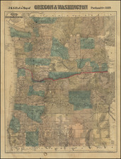
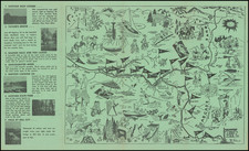
Highly detailed map of Oregon, published by Rand McNally & Co.
The map shows towns, railroads, mountains, rivers, lakes, roads, Native American Reservations, etc.
In the decade pror to 1883, several new counties had been created in Oregon. In 1870, there were 28 counties in the state; by 1883, that number had increased to 34. The new counties included Grant, Harney, Lake, and Wallowa, among others. These new counties reflected the growing population and expanding settlement of the state during this period.
The early 1880s also saw the expansion of railroads in Oregon. The Oregon and California Railroad had been completed in 1883, connecting California to the Willamette Valley and the coast. The Northern Pacific Railroad had also completed its transcontinental line through Oregon in 1883, further connecting the state to the rest of the country.
The early 1880s also marked a period of change for Native American tribes in Oregon. Many tribes had been forcibly removed from their ancestral lands and placed on reservations, including the Klamath, Warm Springs, and Grand Ronde tribes.
The timber and mining industries were also growing rapidly in Oregon in the early 1880s. Timber was a major industry in the state, with vast forests of fir, pine, and other trees covering much of the region. Mining was also a major industry, with rich deposits of gold, silver, and other minerals found throughout the state. The discovery of gold in the eastern part of the state in the early 1860s had led to a gold rush and the establishment of several mining towns.
Rand McNally & Co. is a large American map and navigation company best known for its annual atlases. The company got its start in 1856, when William Rand opened a print shop in Chicago. He was joined in 1858 by a new employee, Andrew McNally. Together, the men established their namesake company in 1868. Originally, the company was intended to print the tickets and timetables for the trains running to and through Chicago; their first railway guide was published in 1869.
By 1870, they had shifted from just printing to publishing directories, travel guides, and newspapers. Their first map appeared in 1872 in a railway guide. The map was produced using a new wax engraving method, a cheaper process that gave the company an edge.
By 1880 Rand McNally had entered the education market with globes, wall maps, and geography texts for students. In 1923, Rand McNally published the first Goode’s World Atlas, named after its editor, Dr. J. Paul Goode. For generations afterward, this would be the standard classroom atlas.
In 1899, William Rand left the company, but McNally and his family remained, controlling the company for over a century. In 1904, they published their first road map intended for automobiles and by 1907 were publishing Photo-Auto Guides, which combined photography and mapping to help drivers. In 1924, they produced the Auto Chum, a precursor to their famous road atlases. Rand McNally would remain the leader in road maps and atlases throughout the twentieth century.
In 1937, Rand McNally opened its first store in New York City. Ever on the frontier of technology, Rand McNally pioneered the scribing process for printing tickets in 1958 and printed their first full-color road atlas in 1960. Arthur Robinson developed his now-famous projection of Rand McNally in 1969. By the 1980s, the company was exploring digital reproduction and digital databases of maps for truckers. In the 1990s, they lead the charge to develop trip-planning software and websites. Today, most of its products are available online or in a digital format, including maps for tablets and phones.
![[Alaska to San Diego and San Qunitin, British Columbia] A Chart Shewing Part of the Coast of N.W. America, with the Tracks of His Majesty's Sloop Discovery and Armed Tender Chatham . . . (First Modern Map of the West Coast of North America)](https://storage.googleapis.com/raremaps/img/small/102067.jpg)