|
||

|

|
|

|
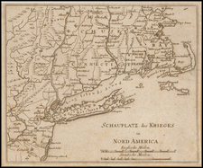
Scarce 1757 woodcut map from the Gentleman's Magazine, depicting the Forts Ontario and Oswego along the River Onondaga in New York, providing a detailed glimpse into the geography and military history of the region during the French and Indian War.
The map offers a visual representation of the strategically significant Fort Oswego and Fort Ontario, both located in the Great Lakes region of North America. Fort Oswego, established in 1727 under the orders of New York Governor William Burnet, served as an 18th-century trading post and British presence in the region. In 1756, during the French and Indian War, the fort's garrison was defeated by a combined force of French and Native American troops. Over one hundred British soldiers were killed, and the French took 1,500 British prisoners before destroying the fort.
Fort Ontario, situated on the east side of the Oswego River, was built in 1755 to reinforce the defenses around the east end of Lake Ontario. Initially named the "Fort of the Six Nations," it was destroyed by French forces during the Battle of Fort Oswego in 1756 and later rebuilt by the British in 1759. This woodcut map captures these forts and their surrounding landscapes during a pivotal time in their history.
The Gentleman’s Magazine was a British publication that helped to normalize the use of maps in support of articles and features. It was founded in 1731 by the prominent London publisher Edward Cave, a pioneer in periodical journalism. The magazine continued in print for nearly two centuries, shuttering production in 1922.
This was the publication which first used the word “magazine”, from the French for storehouse. Cave wanted to create a storehouse of knowledge and he employed some of London’s best writers to fill his pages: Samuel Johnson gained his first regular employment by writing for the Gentleman’s Magazine. Other famous contributors included Jonathan Swift.
The publication covered a broad range of topics, from literature to politics, and, from 1739, frequently used maps as illustrations. The first map they printed was a woodcut of Crimea; the second was a fold-out map of Ukraine by Emanuel Bowen. Maps were used to show battle lines, to chronicle voyages, and to educate about areas with which Britain traded. Certain geographers, like Thomas Jefferys, contributed several maps to the publication.
![[ New York Harbor ] Entree de la Riviere D'Hudson depuis la Pointe Sandy Hook jusqu'a New York les Bancs, les Sondes les Guides &c. . . 1778](https://storage.googleapis.com/raremaps/img/small/78970.jpg)
![(New York-Robert C. Livington) [Revolutionary-Era Land Indenture]](https://storage.googleapis.com/raremaps/img/small/91957.jpg)