


|
||

|

|
|

|
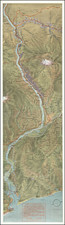
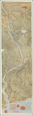
Large format detailed map of Oregon, published by Rand, McNally & Company.
The map shows towns, rivers, railroads, mountains, lakes, etc.
One of the most notable changes that occurred in Oregon during the 1890s was the formation of several new counties. In 1893, Wheeler County was created from parts of Grant, Gilliam, and Crook counties. This new county was named after Henry H. Wheeler, who was the chief justice of the Oregon Supreme Court at the time. The creation of Wheeler County was significant because it marked the first time that a new county had been formed in Oregon since 1885.
In 1899, Sherman County was created from parts of Wasco County. This new county was named after William Tecumseh Sherman, who was a Union Army general during the American Civil War.
Another significant change that occurred in Oregon during the 1890s was the expansion of the state's railroad system. In 1890, the Oregon Short Line Railroad was completed, linking Granger, Wyoming to Huntington, Oregon. This new railroad provided a direct connection between the Union Pacific Railroad and the Oregon Railroad and Navigation Company, which ran from Portland to Huntington.
In 1892, the Oregon and California Railroad completed a line from Eugene to Ashland, connecting the Willamette Valley to Southern Oregon. In 1893, the Astoria and Columbia River Railroad was completed, providing a direct rail connection between the city of Astoria and Portland.
In 1899, the Spokane, Portland and Seattle Railway was completed, connecting Spokane, Washington to Portland, Oregon. This new railroad provided a direct connection between the Inland Empire and the Pacific Northwest.
Rand McNally & Co. is a large American map and navigation company best known for its annual atlases. The company got its start in 1856, when William Rand opened a print shop in Chicago. He was joined in 1858 by a new employee, Andrew McNally. Together, the men established their namesake company in 1868. Originally, the company was intended to print the tickets and timetables for the trains running to and through Chicago; their first railway guide was published in 1869.
By 1870, they had shifted from just printing to publishing directories, travel guides, and newspapers. Their first map appeared in 1872 in a railway guide. The map was produced using a new wax engraving method, a cheaper process that gave the company an edge.
By 1880 Rand McNally had entered the education market with globes, wall maps, and geography texts for students. In 1923, Rand McNally published the first Goode’s World Atlas, named after its editor, Dr. J. Paul Goode. For generations afterward, this would be the standard classroom atlas.
In 1899, William Rand left the company, but McNally and his family remained, controlling the company for over a century. In 1904, they published their first road map intended for automobiles and by 1907 were publishing Photo-Auto Guides, which combined photography and mapping to help drivers. In 1924, they produced the Auto Chum, a precursor to their famous road atlases. Rand McNally would remain the leader in road maps and atlases throughout the twentieth century.
In 1937, Rand McNally opened its first store in New York City. Ever on the frontier of technology, Rand McNally pioneered the scribing process for printing tickets in 1958 and printed their first full-color road atlas in 1960. Arthur Robinson developed his now-famous projection of Rand McNally in 1969. By the 1980s, the company was exploring digital reproduction and digital databases of maps for truckers. In the 1990s, they lead the charge to develop trip-planning software and websites. Today, most of its products are available online or in a digital format, including maps for tablets and phones.


![[ Early Automobile Tourism -- Pacific Coast Highways ] (Strip Maps, etc.)](https://storage.googleapis.com/raremaps/img/small/81461.jpg)