|
||

|

|
|

|
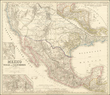
A Remarkable and Short-Lived Idaho Configuration. With Contemporary Annotations Marking Bannack and Virginia Cities.
Colton's remarkable and very rare 1864 map of the United States and Mexico, published in the midst of the Civil War and including one of the earliest, and most unusual, appearances of Idaho Territory.
The map adheres to the Colton legacy of producing cutting-edge geopolitical representations of the American West. In addition to the extremely rare Idaho configuration, the map displays a number of other, less rare anomalies, such as a truncated Nevada, elongated Utah, shortened Nebraska, and the combined Dakota Territory.
The detail is fantastic throughout. Of particular interest are the many routes shown, which include:
- The Pony Express
- Route from Independence, Missouri to Oregon via South Pass (the Oregon Trail)
- Proposed Pacific Railroads through Colorado, the Southwest, and the northern states.
- Cooke's Wagon Road
In addition, there remains a constellation of well-marked forts throughout the region. Areas of economic interest are marked in the west, including an oil spring in Wyoming, and coal mines in Washington.
The Civil War context is critical in understanding this map. Seven of the eight insets shown on the map relate to critical conflict areas, including the DMV area, Charleston, Beaufort, Norfolk, Wilmington (North Carolina), Key West and Tortugas, Mobile Harbor, and New Orleans. Data regarding the relative populations of enslaved peoples and freemen in the southern states are noted to the left of the map. In fact, editions of the map between 1860 and 1862 were colored according to slave and free states.
The final inset shows a partial world map centered on the Atlantic and notes famous 18th- and 19th-century voyages up to the tracks taken by the USS Vincennes in 1838 and 1842. The map also tracks the day-by-day laying of the Atlantic Telegraph in 1858.
Formation of the Idaho Territory
The oversized Idaho Territory was an extremely ephemeral feature on American maps, as it was created in March 3rd, 1863, before being subdivided with the creation of the Montana Territory in May of 1864. Even in 1863, there was disagreement about how to map the Idaho Territory, with some of the other maps from that year showing a "step" configuration to the state.
The Territory sprang out of the mad rush to the region caused by the discovery of gold in northern present-day Idaho in 1860 and the larger discovery in the Boise Basin in 1862. The discovery of further gold east of the Continental Divide led to the foundation of the Montana Territory soon after (May 26, 1864). The Wyoming Territory was formed in 1868.
A number of toponyms appear throughout the Territory. Only Fort Laramie, Fort McKenzie, Fort Union, and Camp Walbach are marked as official forts, but Ft. Owen, Ft. Kootaine, and Fort "Boisee" (founded in 1863) are also denoted. The Three Tetons and Three Buttes are shown. Passes through the Rocky Mountains are Marias, Lewis & Clark, Hell Gate, Cadotts, and South. Big Hole Prairie is marked in just south of present-day Butte.
Virginia City and Bannack
Both Virginia City and Bannack were short-lived centers of early Montana interest. Bannack, today a ghost town, came first when it was founded in 1862 during a major gold discovery. When founded, it was extremely remote and the terminus of the Montana Trail. Despite this, the population rapidly boomed to about 10,000 and served as the first capital of the Montana Territory.
Virginia City was founded by prospectors who had ventured from Bannack and discovered gold. It was founded immediately thereafter and became a boomtown. Both Virginia City (originally named Verina after the First Lady of the Confederacy) and Bannack were particularly notable as lawless mining centers that were the center of the Montana Territory in the 1860s and '70s.
Rarity
We locate only four examples of the 1864 edition of Colton's map through OCLC and other means. However, the existence of variants of the 1864 edition means that not all (if any) of the other examples show the Idaho configuration in question.
The example held by Yale is in publisher's hand-color with Idaho, Montana, and Wyoming all separated. The example held by the Osher Map Library includes the newly-formed Montana Territory and extends the Dakota territory into Wyoming. It also includes the addition of Bannack City, Nevada, Virginia, and various other cities in southwestern Montana. We have not been able to ascertain the configurations shown on the examples held by the Kansas State Historical Society or the Boston Public Library.
We are unaware of any examples of this edition of the map having previously traded.
G. W. & C. B. Colton was a prominent family firm of mapmakers who were leaders in the American map trade in the nineteenth century. Its founder, Joseph Hutchins Colton (1800-1893), was a Massachusetts native. Colton did not start in the map trade; rather, he worked in a general store from 1816 to 1829 and then as a night clerk at the United States Post Office in Hartford, Connecticut. By 1830, he was in New York City, where he set up his publishing business a year later.
The first printed item with his imprint is dated 1833, a reprint of S. Stiles & Company’s edition of David Burr’s map of the state of New York. He also printed John Disturnell’s map of New York City in 1833. Colton’s next cartographic venture was in 1835, when he acquired the rights to John Farmer’s seminal maps of Michigan and Wisconsin. Another early and important Colton work is his Topographical Map of the City and County of New York and the Adjacent Country (1836). In 1839, Colton began issuing the Western Tourist and Emigrant’s Guide, which was originally issued by J. Calvin Smith.
During this first decade, Colton did not have a resident map engraver; he relied upon copyrights purchased from other map makers, most often S. Stiles & Company, and later Stiles, Sherman & Smith. Smith was a charter member of the American Geographical and Statistical Society, as was John Disturnell. This connection would bear fruit for Colton during the early period in his career, helping him to acquire the rights to several important maps. By 1850, the Colton firm was one of the primary publishers of guidebooks and immigrant and railroad maps, known for the high-quality steel plate engravings with decorative borders and hand watercolors.
In 1846, Colton published Colton’s Map of the United States of America, British Possessions . . . his first venture into the wall map business. This work would be issued until 1884 and was the first of several successful wall maps issued by the firm, including collaborative works with D.G. Johnson. From the 1840s to 1855, the firm focused on the production of railroad maps. Later, it published a number of Civil War maps.
In 1855, Colton finally issued his first atlas, Colton’s Atlas of the World, issued in two volumes in 1855 and 1856. In 1857 the work was reduced to a single volume under the title of Colton’s General Atlas, which was published in largely the same format until 1888. It is in this work that George Woolworth (G. W.) Colton’s name appears for the first time.
Born in 1827 and lacking formal training as a mapmaker, G. W. joined his father’s business and would later help it to thrive. His brother Charles B. (C. B.) Colton would also join the firm. Beginning in 1859, the General Atlas gives credit to Johnson & Browning, a credit which disappears after 1860, when Johnson & Browning launched their own atlas venture, Johnson’s New Illustrated (Steel Plate) Family Atlas, which bears Colton’s name as the publisher in the 1860 and 1861 editions.
J.H. Colton also published a number of smaller atlases and school geographies, including his Atlas of America (1854-56), his Illustrated Cabinet Atlas (1859), Colton’s Condensed Cabinet Atlas of Descriptive Geography (1864) and Colton’s Quarto Atlas of the World (1865). From 1850 to the early 1890s, the firm also published several school atlases and pocket maps. The firm continued until the late 1890s, when it merged with a competitor and then ceased to trade under the name Colton.
![[ Catholic Dioceses and Missions in the United States ] Karte der katholischen Dioecesen und der en Missionen in Nordamerika nach den nuesten geographischen Angaben... 1845](https://storage.googleapis.com/raremaps/img/small/98630.jpg)