


|
||

|

|
|

|
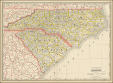
The First Map of the State of North Carolina -- Includes the Moravian Wachovia Tract
Fine example of Mathew Carey's map of North Carolina, the first map of the state published after statehood.
Carey's map of North Carolina, based upon Samuel Lewis' map of 1795, which had been issued in William Guthrie's New System of Modern Geography, published by Matthew Carey. Reid's map provides a large format and highly detailed map of the state, showing towns, roads, rivers, mountains, swamps, counties, meeting houses, and substantial other detail.
Williams & Johnson note that the first state of the Lewis/Carey map does not delineate counties (although they are named). The area around present day Forsyth County is squared off with a dotted line, showing the boundaries of the Moravian Community of Wachovia. The coastline of the Outer Banks shows only a slight eastward slant.
An essential map for North Carolina collectors.
Wachovia Tract
Wachovia Tract was settled by Moravians was somewhat larger than present-day Winston-Salem and somewhat smaller than present-day Forsyth County.
In 1752 Moravian Bishop August Gottlieb "Brother Joseph" Spangenberg led an expedition to locate the area where the Unitas Fratrum, or Moravian church, intended to begin the Wachovia settlements. The Moravian Church in Europe purchased 98,985 acres in the western part of North Carolina, from John Carteret, 2nd Earl Granville.
The nam "Wachovia" was selected to honor Count Zinzendorf, Moravian patron and bishop whose family estate was located in the Wachau region northwest of Vienna, which was inspired when Bishop Spangenberg and the surveying team in 1752 explored the region around the tract.
![[ Cape Hatteras to New York City ] The Coast of the United States of North America; from New York to St. Augustine: Drawn and regulated according to the latest Surveys and Astronomical Observations By Edmund Blunt. Additions to 1839 & 1840](https://storage.googleapis.com/raremaps/img/small/84684.jpg)
![The State of North Carolina from the best Authorities [manuscript annotations]](https://storage.googleapis.com/raremaps/img/small/101026.jpg)

![(Southeast United States) Carte de la partie sud, des Etats Unis de L' amerique septentrionale [Map of the southern part of the United States of North America]](https://storage.googleapis.com/raremaps/img/small/98738.jpg)