|
||

|

|
|

|
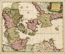
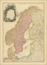
This 1745 map, published by Reiner & Joshua Ottens in Amsterdam, is a scarce sea chart depicting the coast of Finmark, Lapland, and the White Sea. The map was initially created by De Wit and later published by Renard from 1715 to 1739 before being taken over by the Ottens.
The map is beautifully adorned with a decorative cartouche, multiple vignettes featuring sea monsters and sailing ships, and two compass roses, enhancing its visual appeal.
As a sea chart, it would have provided navigational information for sailors along the Finnish coast and the White Sea, reflecting the maritime interests and exploration of the 18th century.
The Ottens brothers, Reiner and Joshua, operated a successful printing partnership in the mid-eighteenth century (fl. 1726-1765). They began the venture in 1726, publishing maps and other prints as “R & I Ottens.” They specialized in the reprinting of others’ work, especially Guillaume De L’Isle. In 1750, Reiner died; his soon, also Reiner, took his place, but the firm began listing their works as “Joshua & Reiner Ottens.” The firm lasted until Joshua’s death in 1765. Joshua’s widow, Johanna de Lindt, sold their remaining stock of plates in 1784.
![[Southern Norway] De Zeecusten van Noorwegen tusschen Der Neus en Schuteness](https://storage.googleapis.com/raremaps/img/small/28923.jpg)