|
||

|

|
|

|
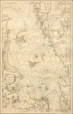
Scarce antique sea chart of the Baltic Sea, embellished by a decorative cartouche, two sailing ships and compass rose.
The map covers the Baltic Sea south of Uusikaupunki ("Nystad"), Finland. St. Petersburg, Stockholm, and Riga ("Ryga") are indicated and labeled.
The cartouche is characteristic of the involved compositions of the Dutch engravers in the latter part of the 17th century. In this case, it shows numerous figures in the local garb of the Baltic.
Originally issued by De Wit, Louis Renard published this map from 1715 to 1739, after which time it was published by Ottens.
The Ottens brothers, Reiner and Joshua, operated a successful printing partnership in the mid-eighteenth century (fl. 1726-1765). They began the venture in 1726, publishing maps and other prints as “R & I Ottens.” They specialized in the reprinting of others’ work, especially Guillaume De L’Isle. In 1750, Reiner died; his soon, also Reiner, took his place, but the firm began listing their works as “Joshua & Reiner Ottens.” The firm lasted until Joshua’s death in 1765. Joshua’s widow, Johanna de Lindt, sold their remaining stock of plates in 1784.
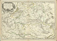
![[ Holy Roman Empire ] Germania del Gastaldo](https://storage.googleapis.com/raremaps/img/small/73754.jpg)
![[Wroclaw Plan] A New & Accurate Map of the North East part of Germany, containing the Dominions of the Electors of Saxony & Brandenburg [and] A Plan of the City of Breslaw Capital of Silefia](https://storage.googleapis.com/raremaps/img/small/80094.jpg)