|
||

|

|
|

|
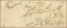
Fine old color example of Ottens's sea chart of the North Sea, first issued by Frederick De Wit in 1675
The chart extends from Norway, Denmark and the German and Dutch Coastlines in the east to Ireland, Scotland and the Faroe Islands. Cherubs hold aloft the coats of arms of Norway, England, Scotland and Ireland, with sailing ships, compass roses and two elaborate cartouches, likely engraved by Romeyn De Hooghe.
The Ottens brothers, Reiner and Joshua, operated a successful printing partnership in the mid-eighteenth century (fl. 1726-1765). They began the venture in 1726, publishing maps and other prints as “R & I Ottens.” They specialized in the reprinting of others’ work, especially Guillaume De L’Isle. In 1750, Reiner died; his soon, also Reiner, took his place, but the firm began listing their works as “Joshua & Reiner Ottens.” The firm lasted until Joshua’s death in 1765. Joshua’s widow, Johanna de Lindt, sold their remaining stock of plates in 1784.
![[Spitzbergen & Wiches Lande]](https://storage.googleapis.com/raremaps/img/small/61990.jpg)