


|
||

|

|
|

|
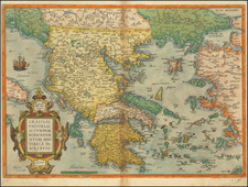
Rare map of the eastern portion of the Roman Empire and contiguous regions.
This map was originally designed by Michel Antoine Baudrand (1633-1700), a French Historian and Geographer, who served as secretary to Cardinal Francesco Barberini (then Dean of the College of Cardinals) in Rome, during which time this map was originally conceived by Baudrand.
The map covers the eastern part of the Roman Empire, including present-day Italy, Greece, Turkey, Syria, Lebanon, Israel, Jordan, Iraq, Iran, and parts of Egypt and Saudi Arabia. The map is highly detailed, with mountains, rivers, lakes, and cities all clearly marked. The names of cities, regions, and countries are written in Latin, and the map also includes descriptive notes about the various regions and their histories. The eastern Mediterranean is prominently featured, with Cyprus, Crete, and the Aegean islands depicted in great detail.
The map also shows the various geographical features of the eastern part of Roman Empire, including mountains, rivers, lakes, and coastlines. The map provides a detailed and accurate portrayal of the size and complexity of the Roman Empire at its peak, and serves as a valuable resource for understanding the political and cultural landscape of the ancient world.
Giacomo Giovanni Rossi (1627-1691) was an Italian engraver and printer. He worked in Rome, the heir to an important printing business founded by his father, Giuseppe de Rossi (1570-1639). Giuseppe began the press in 1633 and Giovanni and his brother, Giandomenico (1619-1653) took it over upon his death. The brothers expanded the business and by the mid-seventeenth century it was the best-known printing house in Rome.
For his maps, Giovanni worked with Giacomo Cantelli da Vignola. They produced the Atlas Mercurio Geografico. The first edition is undated, but the second was issued in 1692, a year after Giovanni’s death. The maps were by Cantelli. The firm also published maps based on those of Nicolas Sanson.
Later, the business passed to Lorenzo Filippo (1682-?). By 1738, the firm was known as Calcografia Camerale, then, from 1870 to 1945, as the Regia Calcografica. Today, the firm is still in business and is called Calcografia Nazionale. It operates as a free museum and offers one of the best collections of prints and plates in the world.
![Candia [Heraklion] | Corphu [Corfu]](https://storage.googleapis.com/raremaps/img/small/77540.jpg)
![Descriptio totius Italiae [bound with:] Rerum Moscoviticarum commentarij ... quibus Russiae ac Metropolis eius Moscoviae descriptio, Chorographicae tabulae, Religionis indicatio, Modus excipiendi & tractandi oratores, Itineraria in Moscoviam duo, & alia quaedam continentur](https://storage.googleapis.com/raremaps/img/small/93228.jpg)
![[Kingdom of Crete, Santorini, etc.] Isle et Royaume de Candie, tiree de divers Memoires . . .](https://storage.googleapis.com/raremaps/img/small/98170.jpg)
![[ Mongolia & China ] Tartaricus](https://storage.googleapis.com/raremaps/img/small/97226.jpg)