|
||

|

|
|

|
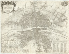
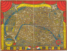
Tracking the Expansion of Paris over the Centuries
Fine plan of Paris, locating 130 monuments and points of interest.
The map shows Paris at 9 points in its history, with a key at the bottom identifying by color the limits of the city during various times, including:
- Roman Times
- Louis IV (12th Century)
- Philippe Auguste (1180-1223)
- Charles V and VI (14th Century)
- Louis XIII (1610-43)
- Louis XIV (1643-1715)
- Louis XV (1715-1774)
- Louis XVI (1774-1792)
- Louis XVIII and Charles X (1814-30)
Ambroise Tardieu was an important French cartographer and engraver.
He produced a number of excellent large format maps, including a revised edition of Aaron Arrowsmith's 4-sheet map of the United States. T
Tardieu came from a family boasting a number of fine engravers, and was trained from an early age by his uncle, Pierre Alexandre Tardieu (1756–1844), a leading French engraver. Showing considerable talent in this field, Ambroise persevered and became a celebrated engraver of portraits. In addition he was appointed as geographical engraver for the French government, for which he received a small stipend. In order to eke out this meagre wage, he began to trade in prints, books and maps. He is remembered for more than 800 portraits engraved through his career, many depicting scientists of the period.
Tardieu published a number of atlases, one of which appeared in 1842 and was titled Atlas universel de geographie, ancienne et moderne/dresse par Ambroise Tardieu pour l'intelligence de la Geographie universelle par Malte-Brun.
![[The Execution of Jean de Poltrot in Paris on March 18, 1563] Richtung des Meray Poltroc genant gescheen zu Paris den 18 Marzens 1563.](https://storage.googleapis.com/raremaps/img/small/78588.jpg)