|
||

|

|
|

|
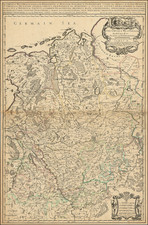
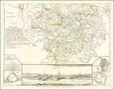
Detailed mid-18th Century map of the Circle of Westphalia, a political and administrative region in Germany during the Holy Roman Empire era. T
he map shows the various counties, bishoprics, principalities, and duchies that were part of the region during the 18th century.
The Circle of Westphalia was one of the ten imperial circles established by the Holy Roman Emperor in the 16th century to better organize the governance of the Empire. The Westphalian Circle included various territories in present-day Germany, including parts of Lower Saxony, North Rhine-Westphalia, and Hesse.
The map shows the different counties in the region, including Ost Frise, Oldenbourg, Benthem, Oye, Lippe, Teklenbourg, and la Mark. The bishoprics of Munster, Osnabrug, and Paderborn are also depicted, as well as the principalities of Minden and the duchies of Berg, Westphalia, and Cleves.
The different geographic regions on the map highlight the diverse landscape of the region, including forests, rivers, and mountains. The River Weser, which flows through several of the counties, is a prominent feature on the map. The Harz Mountains, which were an important source of mining and metallurgy during the period, are also visible.