


|
||

|

|
|

|
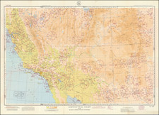
Vibrant bird's-eye view map of California south of Sacramento, showing the route between San Francisco and San Diego, with mountains stretching out to the horizon in the background.
The San Francisco Convention & Tourists Bureau produced the map for the 1935 California Pacific International Exposition held in San Diego. The map highlights the roads through the Santa Clara Valley and the Central Valley up from Southern California and the San Diego Fair. The intent to entice some of the visitors to San Diego up to San Francisco is clear enough.
The map is a wonderfully colorful and lively rendition of the southern half of the state, capturing the varied topography and landscape of the state.
Rarity
Not in Rumsey. The map is rare, this being the first time we have had it.
![[Imperial and San Bernardino Counties] Sketch To Accompany Report of Reconnaissance Head Gate Crossing of Colorado River To Bristol, Cal. March 20, 1903](https://storage.googleapis.com/raremaps/img/small/31857.jpg)
