This item has been sold, but you can enter your email address to be notified if another example becomes available.


|
||

|

|
|

|
Stock# 92528
Description
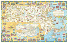
Detailed map of Vashon Island and Maury Island, at the southern most part of Puget Sound, drawn by Joy Billingsley and revised by D.J. Sweeny.
The map contains a detailed plan of the two islands, with a legend noting local points of interest, such as grocery stores, gas, water, housing projects, factories, moorages, the army post, bus routes, paved and gravel roads.
The map also locates the radio towers for KOMO, KVI, KIRO, and KING.
At the top, the dferry route from Seattle to Harper is noted, with a proposed cross sound bridge, which was apparently never built.

![[Cultural Revolution Maps - Map of France / A Sketch Map of Events of May 1968] [Fagu di tu - Faguo ren min ge ming dou zheng yi tu]](https://storage.googleapis.com/raremaps/img/small/88909.jpg)