|
||

|

|
|

|
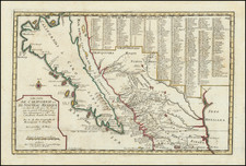
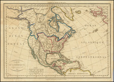
Fine Instructional Map of North America, Emphasizing the English Holdings and Latest Discoveries
Nice example of the second state of Edward Wells’ map of North America, intended as an instructional map for students. Wells produced the school atlas in which this was included in 1700 and it was reprinted and highly recommended by educators at the time.
The map shows the entirety of the North American continent, or as much as was then known to Europeans. In general outline, the map follows Louis Hennepin’s Carte d’un tres grand Pays entre le Nouveau Mexique (1697) and his Carte d’un tres grand Pais (1697). Hennepin’s influence is especially evident in the Mississippi River area, which its origin in Texas, and the eastern seaboard; Hennepin’s name is directly mentioned near the Great Lakes.
However, Wells also called on other sources, so as to include recent details like the French settlement at Biloxi in 1699, marked here as “New French Settlement” near the Gulf of Mexico. He also deviates from Hennepin in the shape and course of the Ohio River. Here it is called the Hotico River and runs east-west, alongside the also east-west, and surprisingly long, Appalachian Mountains.
The Eastern seaboard contains the latest settlements and is split into colonies including Carolina, Virginia, Maryland, Pennsylvania, New York, New England, and continuing north to New Scotland and New Foundland. Towns include Charlestown, Jamestown, Baltimore, Philadelphia, New York, Milford, Plymouth, Boston, and others.
French presence is downplayed on the map in favor of English, as can be seen with the small size of New France and the blocking of the French from access to the Gulf of Mexico. The territories are drawn so as to maximize English possession. For example, the island of California is labeled New Albion, after the point named by Francis Drake on his circumnavigation in 1577. Mainland New Mexico is “of a barren soil and little known.” To the north, New Brittain, New South Wales, and New North Wales squish New France, allowing English access to the “Northern Unknown Continent” and the “Parts as Yet Unknown” in the Pacific Northwest.
Besides the geographic features there is a quaint abbreviations cartouche to help the young reader discern the various bays, mountains, and archbishoprics. There are also helpful annotations around the map, citing dates of first European contact and demarking which monarchy nominally controlled which areas.
In the Pacific Northwest, covering the parts unknown, is an elaborate cartouche topped with the coat of arms of Prince William, Duke of Gloucester, second in line to the throne of England when this map was originally drafted. Gloucester, who was tutored at home in Windsor, studied geography, so he is a likely subject for Wells’ attention. However, Gloucester died of a sudden fever in 1700, bringing about a succession crisis which was resolved with the Act of Settlement of 1701, the legislation that made way for the House of Hanover. Later editions of the atlas retained the dedication, despite Gloucester’s death.
States of the map
There are four known states of this map, according to Burden. This is an example of the second state.
- State 1 (1700) has no plate number under the cartouche.
- State 2 (1701) has a number 39 below the cartouche. Frobishers Straits have been added near Greenland and the Great Lakes have names.
- State 3 (1704) has additional toponyms near the Great Lakes.
- State 4 (ca. 1743) has the colony of Georgia added, with additional settlements labeled in New Foundland, Labrador, and Nova Scotia. The north of Hudson’s Bay has been reworked and California has additional named places, including the Strait of Anian.
This is a fascinating mix of geographic instruction and fancy intended for a student audience. It is an instructive glimpse into eighteenth-century instruction.
The popular misconception of California as an island can be found on European maps from the sixteenth through the eighteenth centuries. From its first portrayal on a printed map by Diego Gutiérrez, in 1562, California was shown as part of North America by mapmakers, including Gerardus Mercator and Abraham Ortelius. In the 1620s, however, it began to appear as an island in several sources. While most of these show the equivalent of the modern state of California separated from the continent, others, like a manuscript chart by Joao Teixeira Albernaz I (ca. 1632) now in the collection of the National Library of Brasil shows the entire western half of North Americas as an island.
The myth of California as an island was most likely the result of the travel account of Sebastian Vizcaino, who had been sent north up the shore of California in 1602. A Carmelite friar, Fray Antonio de la Ascensión, accompanied him. Ascension described the land as an island and around 1620 sketched maps to that effect. Normally, this information would have been reviewed and locked in the Spanish repository, the Casa de la Contratación. However, the manuscript maps were intercepted in the Atlantic by the Dutch, who took them to Amsterdam where they began to circulate. Ascensión also published descriptions of the insular geography in Juan Torquemada’s Monarquia Indiana (1613) (with the island details curtailed somewhat) and in his own Relación breve of ca. 1620.
The first known maps to show California as an island were on the title pages of Antonio de Herrera’s Descripción de las Indias Occidentales (1622) and Jacob le Maire's Spieghel Der Australische Navigatie (1622). Two early examples of larger maps are those by Abraham Goos (1624) and another by Henry Briggs, which was included in Samuel Purchas’ Hakluytus Posthumus or Purchas his Pilgrimes (1625). In addition to Briggs and Goos, prominent practitioners like Jan Jansson and Nicolas Sanson adopted the new island and the practice became commonplace. John Speed’s map (1626-7), based on Briggs’ work, is well known for being one of the first to depict an insular California.
The island of California became a fixture on mid- and late-seventeenth century maps. The island suggested possible links to the Northwest Passage, with rivers in the North American interior supposedly connecting to the sea between California and the mainland. Furthermore, Francis Drake had landed in northern California on his circumnavigation (1577-80) and an insular California suggested that Spanish power in the area could be questioned.
Not everyone was convinced, however. Father Eusebio Kino, after extensive travels in what is now California, Arizona, and northern Mexico concluded that the island was actually a peninsula and published a map refuting the claim (Paris, 1705). Another skeptic was Guillaume De L’Isle. In 1700, De L’Isle discussed “whether California is an Island or a part of the continent” with J. D. Cassini; the letter was published in 1715. After reviewing all the literature available to him in Paris, De L’Isle concluded that the evidence supporting an insular California was not trustworthy. He also cited more recent explorations by the Jesuits (including Kino) that disproved the island theory. Later, in his map of 1722 (Carte d’Amerique dressee pour l’usage du Roy), De L’Isle would abandon the island theory entirely.
Despite Kino’s and De L’Isle’s work, California as an island remained common on maps until the mid-eighteenth century. De L’Isle’s son-in-law, Philippe Buache, for example, remained an adherent of the island depiction for some time. Another believer was Herman Moll, who reported that California was unequivocally an island, for he had had sailors in his offices that claimed to have circumnavigated it. In the face of such skepticism, the King of Spain, Ferdinand VII, had to issue a decree in 1747 proclaiming California to be a peninsula connected to North America; the geographic chimera, no matter how appealing, was not to be suffered any longer, although a few final maps were printed with the lingering island.
Edward Wells was a Church of England clergyman and advocate for education. He published prolifically, including several atlases of the ancient and contemporary world. Wells was the son of a vicar and entered Christ Church, Oxford in late 1686. He graduated BA in 1690, MA in 1693, and worked as a tutor at his college from 1691 to 1702. Then, he entered into a living at Cotesbach, Leicestershire, from where he continued to publish his many works. He attained the degrees of BD and DD in 1704, after he was already at Cotesbach.
From roughly 1698 onward, Wells wrote many sermons, books, and atlases. He focused on catechismal and pastoral works, as well as educational books. For example, some of his first works were mathematics texts for young gentlemen, which included how to use globes and determine latitude and longitude. He also translated classical and Christian texts, sometimes adding geographical annotations.
His descriptive geographies were not overly original works, but they were popular in their time. First, he produced a Treatise of Antient and Present Geography in 1701; it went on to four more editions. Next was a Historical Geography of the New Testament (1708), accompanied by a Historical Geography of the Old Testament (1711-12).
![[ Chinese Voyages To America, etc. ] Memoires De Litterature, Tires Des Registres De L'Academie Royale Des Inscriptions et Belles-Lettres Depuis l' annee M. DCC. XVIII. julques & compris l'annee M. DCC. XXV Tome Quarante-Neuvieme](https://storage.googleapis.com/raremaps/img/small/101296.jpg)