|
||

|

|
|

|
Stock# 92485
Description
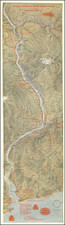
An exceptional pictorial map / view of the Canadian Rocky Mountains and British Columbia, published by the Canadian Pacific Railway in 1921.
The map extends from Victoria, Seattle and the Straits of Georgia and Juan de Fuca to Calgary and Edmonton, highlighting the routes of the Canadian Pacific Railway in the region.
The map provides a remarkable treatment of rugged topography of the region, noting Mountains, Glaciers, Rivers, Roads and Railroad lines. Within the lakes in the region, Steamer Service lines are illustrated.
Includes two separate tables of distances.
Condition Description
Two small areas of loss of printed image at bottom left and minor loss along folds.
![[Washington & Oregon] Amer. Sep. No. 38. Partie Des Etats-Unis](https://storage.googleapis.com/raremaps/img/small/93549.jpg)
![[ Lake Hancock / Middle Fork Snoqualmie River / Kings County ] Township No. 24 North, Range No. 9 East. Willamette Meridian, Washington](https://storage.googleapis.com/raremaps/img/small/101646.jpg)