|
||

|

|
|

|
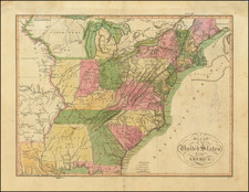
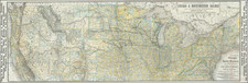
This 1822 edition of John Melish's influential map of the United States offers a detailed and historically significant representation of the nation's early territorial expansion, informed by the latest explorations and discoveries of the time.
John Melish's map, first issued in 1812 and regularly updated over the next decade, reflects the evolving knowledge of the United States' territories as well as the ambitions that shaped the country's westward expansion. This 1822 edition incorporates information from prominent explorers and scholars, including Lewis and Clark, Zebulon Pike, and Alexander von Humboldt. The map's extent westward reveals the developing territories of the northwest, Missouri, Arkansas, and the Mexican province, which includes Texas.
Melish's map holds a particular significance in American cartography as it visually embodies the concept of Manifest Destiny. As one of the foremost mapmakers of the 1810s and 1820s, Melish played a crucial role in shaping the understanding and representation of the United States during a period of rapid growth and territorial acquisition. His 1816 large format map of the US is widely regarded as the most important American map of the 19th century.
The 1822 edition of the map, published in Philadelphia, carries the distinction of being officially entered according to the Act of Congress on July 10, 1818. This work not only offers a valuable historical snapshot of the United States during its formative years, but also stands as a testament to the vision and craftsmanship of a key figure in American cartography, John Melish.
John Melish (1771-1822) was the most prominent American mapmaker of his generation, even though his cartographic career lasted only a decade. Melish was born in Scotland; he moved to the West Indies in 1798 and then to the United States in 1806. By 1811, he had settled in Philadelphia and published Travels through the United States of America, in the years 1806 & 1807, and 1809, 1810, & 1811, which was richly illustrated with maps.
Melish created several regional maps of the highest quality, as well as the Military & Topographical Atlas of the United States (Philadelphia, 1813, expanded 1815). The latter work is widely considered to be the finest cartographic publication to come out of the War of 1812.
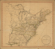
By far his best-known work is his monumental map of the United States of 1816, Map of the United States with the contiguous British and Spanish Possessions. He began working on the map in 1815 and sent it to Thomas Jefferson for comment in 1816. Jefferson enthusiastically reviewed the map and returned it with his edits. Jefferson later hung an example of the map in the Entrance Hall of Monticello and sent it to associates in Europe.
Melish’s finished product was the first map of the United States to extend to the Pacific Ocean. After its publication in 1816, Melish ensured the map was as up-to-date as possible; it was reissued in 25 known states published between 1816 and 1823. The map captured the then rapidly changing geography of the United States, as well as various boundary disputes, treaties, and expansion.