


|
||

|

|
|

|
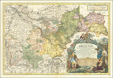
Finely detailed map of Upper Silesia, published by Jean Beaurain, geographer to the King of France.
The map illustrates the various principalities, duchies, and seigneuries that comprised the upper part of the Duchy of Silesia. Each of the duchies and seigneuries on the map was significant in its own right, and their identification is crucial to understanding the historical context of the region.
The first duchy referenced on the map is Oppeln, which was situated in the western part of the Duchy of Silesia. Oppeln was a significant duchy and was known for its impressive fortifications, including a large castle that served as the residence for the dukes of Oppeln.
The second duchy mentioned is Ratibor, which was located in the northern part of Silesia. Ratibor was known for its beautiful architecture, including a stunning castle that was the residence of the dukes of Ratibor.
The third duchy is Iagerndorf, which was situated in the eastern part of the Duchy of Silesia. Iagerndorf was known for its beautiful castle, which was built in the Renaissance style and served as the residence of the dukes of Iagerndorf.
The fourth duchy referenced on the map is Troppau, which was located in the southeastern part of Silesia. Troppau was a significant duchy and was known for its beautiful architecture, including a magnificent castle that was the residence of the dukes of Troppau.
The fifth duchy is Teschen, which was situated in the southern part of Silesia. Teschen was a vital duchy and was known for its beautiful architecture, including a stunning castle that was the residence of the dukes of Teschen.
The sixth duchy is Munsterberg, which was located in the northwestern part of Silesia. Munsterberg was known for its impressive castle, which was built in the Gothic style and served as the residence of the dukes of Munsterberg.
The seventh and final duchy referenced on the map is Neisse, which was situated in the central part of the Duchy of Silesia. Neisse was a significant duchy and was known for its beautiful architecture, including a magnificent castle that was the residence of the dukes of Neisse.
Additionally, the map illustrates two seigneuries, Plesse and Ober-Beuthen, that were significant in the region. Plesse was located in the southern part of the Duchy of Silesia and was known for its beautiful castle, which was built in the Renaissance style and served as the residence of the dukes of Plesse. Ober-Beuthen, on the other hand, was situated in the eastern part of the Duchy of Silesia and was known for its impressive castle, which was built in the Gothic style and served as the residence of the dukes of Ober-Beuthen.
![(Second World War - Holocaust) Miejsca walk i męczeństwa narodu Polskiego na terenie woj. Opolskiego w latach 1920-1945 [Places of fights and martyrdom of the Polish nation in the province Opolski in the years 1920-1945]](https://storage.googleapis.com/raremaps/img/small/82707.jpg)

![[ Holy Roman Empire ] S. Imperium Romano-Germanicum oder Teutschlenad mit Seinen Angrantzenden Konigreichen und Provincien,...](https://storage.googleapis.com/raremaps/img/small/98433.jpg)
![[ Duchy of Warsaw ] Polen im Herzogthum Warschau und unter Oestreich und Russland getheilt](https://storage.googleapis.com/raremaps/img/small/98514.jpg)