|
||

|

|
|

|
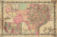
Rare and detailed oil and gas development map of the Permian Basin, showing the known spread of oil and gas fields as of 1956.
The map provides valuable insights into the distribution of oil fields, gasoline plants, and carbon black plants across West Texas and Southeast New Mexico. The map uses various symbols to indicate different features, with oil fields marked green, and gas fields marked red, and the locations of various plants all indicated. Key geographical landmarks, such as the Delaware Basin, Northwest Shelf Area, North Platte, and Sheffield Channel, are also clearly shown on the map. The map provides an understanding of the energy resources and infrastructure in West Texas, capturing a snapshot of the area's industrial landscape at the time in a manner that would have been useful for the Texas oil man of the 1950s.
The map was offered both for separate sale and to accompany the December 1956 issue of The Petroleum Engineer.
The Permian Basin and the 1950s Boom
The Permian Basin is one of the most prolific oil and gas-producing regions in the world, located primarily in West Texas and southeastern New Mexico. The Permian Basin consists of several smaller oil fields, including the Spraberry, Wolfcamp, and Bone Spring formations. The basin has a long history of oil and gas production, with drilling activity dating back to the early 1900s. Since then, technological advancements and innovations in hydraulic fracturing and horizontal drilling have allowed for the exploitation of previously uneconomical reserves, leading to a surge in production and development in recent years.
In the 1950s, the Permian Basin saw significant growth and development, thanks to the discovery of large oil and gas reserves in the region. The introduction of new technologies, such as three-dimensional seismic imaging and improved drilling techniques, allowed for the exploration and production of previously inaccessible reservoirs. This led to an increase in drilling activity, with the number of wells in the region growing from just over 2,000 in 1950 to nearly 13,000 by 1960. The development of the Permian Basin in the 1950s had a profound impact on the local economy, bringing in jobs and boosting the region's overall economic growth.