|
||

|

|
|

|
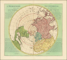
"The Beginning of Wisdom In Cartography Is The Realization That All Maps Without Exception Are Distorted"
A fascinating map of the world, intended as a means of understanding straight line navigation by air in an age when air travel was becoming an essential part of the global landscape.
The map text notes “any straight line on this north-polar gnomic map is a true great circle and thus the shortest route between any two given points.”
As noted by Susan Schulten, “aviation collapsed distance and realigned geographical relationships, and nowhere was this more apparent than in the changing look of maps.” As air navigation and aerial technologies grew, maps necessarily evolved to serve this important market. Richard Edes Harrison was one of the leading map visonaries of the period, with this polar view of the world on a gnomic projection being among his most memorable projections.As noted by David Rumsey, "Richard Harrison produced . . . a unique view of the world for the "air age" . . . [a] precursor of our ubiquitous satellite maps of today, yet hand drawn with great cartographic skill."
Harrison's map was issued as a supplement to the May 1943 issue of Fortune Magazine. In the midst of World War II, when maps illustrating air attacks, distances and theaters of the war were a daily news feature, his image of straight line air travel informed the American wartime public in a manner that was largely absent from other projections.
In its 1943 essay on Harrison's maps to accompany the exhibition Maps For Global War, the Brooklyn Museum wrote:
Through Mr. Harrison’s various maps the layman is freed from the straight-jacket of the conventional flat map with its fixed viewpoint and from the limitations of the familiar Mercator projection.
The Harrison maps are in each ease drawn for a particular purpose, and each presents a specific point of view, crystallized, and that point of view only. Just as the Mercator projection has its limitations, so have the Harrison maps for, as the cartographer says, “Every map has inherent limitations in its projection, and every map has a psychological limitation which develops from the excessive use of one map to the neglect of others.”
. . . Mr. Harrison has designed each map for its purpose regardless of such established conventions as that the north must always be at the top. This drawing of maps from new viewpoints enables the layman to see the present world in its present proportions and not in those of past ages. Strategists and geography teachers no longer need attempt to depict global strategy on the Mercator projection, which utterly ignores the great skyway of the near future, the Arctic.
Mr. Harrison makes no claims that he has discovered new projections. Rather he says that he has “dusted off” old projections which are suited to the modern era of flight. For example, the polar equidistant projection, first drawn by Galeanus in 1510, two years before the birth of Mercator, has been used by Harrison in his “The World Divided” and “One World, One War.”
Mr. Harrison’s maping career began in 1932 when he first made maps for Time and Fortune magazines. From 1934 to 1938 he did almost all of Time’s maps until those for Fortune crowded out that work. He also made the first experimental maps for the “March of Time” newsreel.
In 1940 his “Strategy Map of Europe,” with comment and military information by Major George Fielding Eliot, was published by Reynal and Hitchcock. In the past four years Mr. Harrison has done maps for the following books: “Far Eastern Policy of the U.S.” by A. Whitney Griswold; “Britain and France Between Wars” by A. Wolfers; “A Navy Second to None” by George T. Davis; “America’s Strategy in World Politics” by Nicholas J. Spykman; “Alone” by Admiral Richard E. Byrd; “Geopolitics” by Robert Strausz; “The Queens Die Proudly” by William L. White (to be published); “Retreat to Victory” by Allan Michie (to be published); “Alaska Under Arms” by Jean Potter (to be published); and “Greenland” by Viljhalmur Stefansson (to be published).
Richard Edes Harrison was a distinguished American scientific illustrator and cartographer, widely acknowledged for his innovative data visualization and cartographic methods. Harrison was notably the house cartographer for "Fortune" magazine and served as a consultant at "Life" for nearly two decades. His contributions were pivotal in reshaping cartographic perspectives and influencing spatial thinking.
The son of biologist Ross Granville Harrison, Richard grew up in New Haven and pursued his education at Yale College. He graduated with a major in zoology and a minor in chemistry. Initially, Harrison worked as a draftsman for architect Cass Gilbert and aspired to become an architect himself. This led him to the Yale School of Fine Arts in 1926, where he studied for four years. However, the economic downturn of the Great Depression impacted the field of architecture, prompting Harrison to shift his focus to design work.
Harrison's entry into cartography in 1935 was somewhat serendipitous, stemming from a friend's request to temporarily replace a mapmaker at "Fortune." During World War II, his cartographic visualizations gained significant popularity. He advocated for a multi-perspective approach to geographic issues and critiqued conventional practices, such as the overreliance on the Mercator projection and the standard placement of north at the top of maps.
His groundbreaking work included the azimuthal projection map titled "The World Divided," first published in "Fortune" in August 1941. This map, which was extensively replicated, underscored the United States' central role in global conflict. A later version, "One World, One War," appeared in "Fortune" in March 1942 and was ordered in large quantities by the U.S. Army. Harrison’s design influenced the creation of the United Nations logo and his maps were characterized by their unique tilted perspectives.
Despite considering himself more of an artist than a cartographer, Harrison had a highly successful career in mapmaking. He was part of the staff at "Fortune" from 1936 to 1938 and worked as a map consultant at the State Department and the Office of Strategic Services, the CIA's precursor, in the 1940s and 1950s. His expertise was also sought by the Museum of Modern Art. Harrison lectured at several universities, including Clark, Syracuse, Columbia, and Trinity, and was a member of both the American Geographical Society and the Royal Geographical Society.
His contributions extended to the realm of geopolitics, where he produced maps for Nicholas Spykman's "America's Strategy in World Politics," a seminal work in 20th-century geopolitics. Harrison's legacy in cartography and data visualization remains significant, as he fundamentally challenged and transformed the way maps were perceived and used in understanding world affairs.