|
||

|

|
|

|
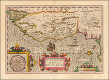
Fascinating view and map of Portuguese settlement of Cacheu, a small town and river in Guinea-Bissau, West Africa, that was an important center of trade and commerce in the 17th and 18th centuries.
The map shows a detailed representation of the mouth of the river and surrounding islands. The names of the islands, Bissos and Bighos, are marked on the map, as are various other features of the landscape, including hills, forests, and rivers.
The "Prospect of the Portuguese Town of Cacheo" is a view of the town from the north, as seen from the river. The town is shown as a collection of huts with a large fort dominating the image. The fort is shown in detail, with its walls, towers, and battlements clearly marked.
For most of the seventeenth and eighteenth centuries, Cacheu was the official slave trading point for the Portuguese in the Upper Guinea region, the point at which the Portuguese crown controlled duties on slave exports. Multiple companies were established to facilitate the trade of slaves from Cacheu to the New World, including that of the Company of Cacheu and Rivers and Commerce of Guinea.
![[Northern Nigeria Protectorate]](https://storage.googleapis.com/raremaps/img/small/70705.jpg)
![The Prospect of the Island of Goeree & the Fort Vermandoise alias St. Michael (with) A Plan of the Island Goeree in Nigritiae (and) [Plan of Fortifications]](https://storage.googleapis.com/raremaps/img/small/92044.jpg)