|
||

|

|
|

|
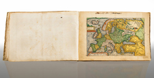
A Handsome Example of the 1541 Edition of Fries’ Adaptation of Waldseemuller’s Ptolemy.
A very clean and attractive example of Fries’ 1541 edition of Ptolemy, including the first map in a Ptolemy atlas to name “America” and the suites of ancient and modern maps.
The so-called “Fries Ptolemy” was first published in 1522 by Johann Koberger. Fries is generally thought to have edited the maps. The 1522 edition of Fries' work is very rare, suggesting that the work was not commercially successful. In 1525, an improved edition was issued, with a re-edit of the text by Willibald Pirckheimer, from the notes of Johannes Regiomontanus. After Grüninger died in 1531, the business was continued by his son Christoph, who seems to have sold the materials for the Ptolemy to two Lyon publishers, the brothers Melchior and Gaspar Trechsel, who published a joint edition in 1535, before Gaspar Trechsel published an edition in his own right in 1541.
Fries was initially a physician, working in various places in the Alsace region and Switzerland before settling in Strasbourg around 1519. He was known for his medical writings and met the Strasbourg printer and publisher Johann Grüninger, who was responsible for printing several of Waldseemuller's maps and supervising the cutting of the maps for the 1513 edition of Ptolemy edited by the St. Die group of scholars, including Walter Lud, Martin Ringmann, and Martin Waldseemuller.
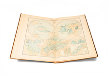
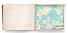
In addition to the book's complement of maps, it includes a full-page armillary sphere showing the inhabited earth by Albrecht Dürer (Meder 262).
The Ancient Maps
Fries' work follows the typical cartographic tradition in Europe in the 15th and early 16th centuries in that it reproduces the maps of Claudius Ptolemy, the famous Greco-Roman mathematician, astronomer, geographer who was active in the 2nd Century AD.
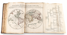
The Modern Maps
Generally, the maps in the modern section are reduced copies by Lorenz Fries of the modern maps that appeared in Martin Waldseemuller’s Ptolemy of 1513, Geographie Opus Novissima. To that group, Fries has added a map of Southeast Asia, East Asia, China, and Japan, and a navigational map of the world.
Collation: 149, [1] pages, 1 leaf; 50 woodcut maps, all but one double-page (Plansipheric world map bound between maps 23 and 24); [avi], [bvi], [cvi], [dvi], [evi], [fvi], [gvi], [hvi] (i.e., complete).
Lorenz (Laurent) Fries (ca. 1485-1532) was born in Mulhouse, Alsace. He studied medicine, apparently spending time at the universities of Pavia, Piacenza, Montpellier and Vienna. After completing his education, Fries worked as a physician in several places before settling in Strasbourg in about 1519. While in Strasbourg, Fries met the Strasbourg printer and publisher Johann Grüninger, an associate of the St. Dié group of scholars formed by, among others, Walter Lud, Matthias Ringmann and Martin Waldseemüller.
From 1520 to 1525, Fries worked with Grüninger as a cartographic editor, exploiting the corpus of material that Waldseemüller had created. Fries' first venture into mapmaking was in 1520, when he executed a reduction of Martin Waldseemüller's wall map of the world, first published in 1507. While it would appear that Fries was the editor of the map, credit is actually given in the title to Peter Apian. The map, Tipus Orbis Universalis Iuxta Ptolomei Cosmographi Traditionem Et Americ Vespucii Aliorque Lustrationes A Petro Apiano Leysnico Elucubrat. An.o Dni MDXX, was issued in Caius Julius Solinus' Enarrationes, edited by Camers, and published in Vienna in 1520.
Fries’ next project was a new edition of the Geographia of Claudius Ptolemy, which was published by Johann Grüninger in 1522. Fries evidently edited the maps, in most cases simply producing a reduction of the equivalent map from Waldseemüller's 1513 edition of the Geographie Opus Novissima, printed by Johann Schott. Fries also prepared three new maps for the Geographia, of Southeast Asia and the East Indies, China, and the world, but the geography of these derives from Waldseemüller's world map of 1507.
The 1522 edition of Fries' work is very rare, suggesting that the work was not commercially successful. In 1525, an improved edition was issued, with a re-edit of the text by Willibald Pirkheimer, from the notes of Regiomontanus (Johannes Müller von Königsberg).
After Grüninger's death in ca. 1531, the business was continued by his son Christoph, who seems to have sold the materials for the Ptolemy to two Lyon publishers, the brothers Melchior and Gaspar Trechsel, who published a joint edition in 1535, before Gaspar Trechsel published an edition in his own right in 1541.
Claudius Ptolemy (fl. AD 127-145) was an ancient geographer, astronomer, and mathematician. He is known today through translations and transcriptions of his work, but little is known about his life besides his residence in Alexandria.
Several of his works are still known today, although they have passed through several alterations and languages over the centuries. The Almagest, in thirteen books, discusses astronomy. It is in the Almagest that Ptolemy postulates his geocentric universe. His geometric ideas are contained in the Analemma, and his optical ideas were presented in five books known as the Optica.
His geographic and cartographic work was immensely influential. In the Planisphaerium, Ptolemy discusses the stereographic projection. Perhaps his best-known work is his Geographia, in eight books. However, Ptolemy’s ideas had been absent from western European intellectual history for roughly a thousand years, although Arab scholars interacted with his ideas from the ninth century onward.
In 1295, a Greek monk found a copy of Geographia in Constantinople; the emperor ordered a copy made and the Greek text began to circulate in eastern Europe. In 1393, a Byzantine diplomat brought a copy of the Geographia to Italy, where it was translated into Latin in 1406 and called the Cosmographia. The manuscript maps were first recorded in 1415. These manuscripts, of which there are over eighty extant today, are the descendants of Ptolemy’s work and a now-lost atlas consisting of a world map and 26 regional maps.
When Ptolemy’s work was re-introduced to Western scholarship, it proved radically influential for the understanding and appearance of maps. Ptolemy employs the concept of a graticule, uses latitude and longitude, and orients his maps to the north—concepts we take for granted today. The Geographia’s text is concerned with three main issues with regard to geography: the size and shape of the earth; map projection, i.e. how to represent the world’s curve proportionally on a plane surface; and the corruption of spatial data as it transfers from source to source. The text also contains instructions as to how to map the world on a globe or a plane surface, complete with the only set of geographic coordinates (8000 toponyms, 6400 with coordinates) to survive from the classical world.
Michael Villanovanus (1511-1553) was born in Aragon, Spain. Villanovanus is often referred to as Servetus. He worked for Trechsel and wrote many of the descriptions on the versos of the maps in Fries's Ptolemy. Servetus was also the editor for the 1541 edition of that Ptolemy, which was published at Vienne.
Servetus was burned at the stake for heresy in 1553. He was charged with 40 counts of heresy, many related to passages in works he had edited or written. One of the counts related to the verso text in the 1535 edition of the Holy Land map "Tab. Ter. Sanctae" number 41, which alleged that Palestine was not as fertile as was generally believed. This passage was removed from the 1541 edition, but had been present in earlier editions which Servetus had not overseen.