|
||

|

|
|

|
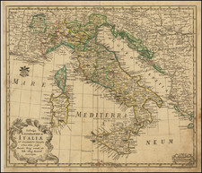
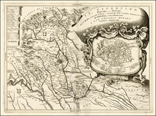
Rare and Provocative Map of Italy
Extremely rare separately map of Italy, first issued in 1607, including a provocative vignette at the lower center.
The map is based upon Gerard Mercator's map of 1589 and Willem Blaeu's wall map of 1606.
The map was first issued in 1607 by Pieter van den Keere (Petrus Kaerius). In 1616, a second state of the map was issued Jansson, with the imprint "Amstelodami excudebat Joannis Janssonius anno 1616" below Sardinia.
In about 1633, Jansson revised the copper plate, removing the decorative borders and re-engraving a simplified title cartouche. Jansson also added an engraved image of Neptune in the Tyrrhenian Sea, provocatively eyeing a sea nymph. A blank cartouche is also added in the lower right corne
The remnants of the 1616 imprint remain visible under Sardinia traces of the abraded address.
Rarity
All states of the map are very rare.
This is the first example of the circa 1633 example we have ever seen.
Jan Janssonius (also known as Johann or Jan Jansson or Janszoon) (1588-1664) was a renowned geographer and publisher of the seventeenth century, when the Dutch dominated map publishing in Europe. Born in Arnhem, Jan was first exposed to the trade via his father, who was also a bookseller and publisher. In 1612, Jan married the daughter of Jodocus Hondius, who was also a prominent mapmaker and seller. Jonssonius’ first maps date from 1616.
In the 1630s, Janssonius worked with his brother-in-law, Henricus Hondius. Their most successful venture was to reissue the Mercator-Hondius atlas. Jodocus Hondius had acquired the plates to the Mercator atlas, first published in 1595, and added 36 additional maps. After Hondius died in 1612, Henricus took over publication; Janssonius joined the venture in 1633. Eventually, the atlas was renamed the Atlas Novus and then the Atlas Major, by which time it had expanded to eleven volumes. Janssonius is also well known for his volume of English county maps, published in 1646.
Janssonius died in Amsterdam in 1664. His son-in-law, Johannes van Waesbergen, took over his business. Eventually, many of Janssonius’ plates were sold to Gerard Valck and Pieter Schenk, who added their names and continued to reissue the maps.
![Descriptio totius Italiae [bound with:] Rerum Moscoviticarum commentarij ... quibus Russiae ac Metropolis eius Moscoviae descriptio, Chorographicae tabulae, Religionis indicatio, Modus excipiendi & tractandi oratores, Itineraria in Moscoviam duo, & alia quaedam continentur](https://storage.googleapis.com/raremaps/img/small/93228.jpg)