


|
||

|

|
|

|
Attractive and scarce antique engraved map of Chioggia and Fossa Clodia in the Veneto Region of Italy.
Chioggia and Fossa Clodia are both cities located in the Venetian Lagoon, near the city of Venice, in northeastern Italy. The title of the map suggests that Chioggia and Fossa Clodia were considered Episcopal Cities, meaning that they were under the jurisdiction of a bishop or were centers of religious authority in the Republic of Venice.
The Republic of Venice was a maritime republic that existed from the 7th century until the end of the 18th century. It was a major power in the Mediterranean and played an important role in the politics and trade of Europe during its existence. This map likely represents one of the many maps that were created during this time to document and represent the territory and power of the Republic of Venice.
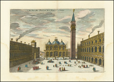
The "Nouveau Theatre de l'Italie" was a collection of maps and views of Italian cities published in Amsterdam by Pierre Mortier in 1704/5. This atlas consisted of four volumes and included maps from the earlier work on Italian cities by Willem Blaeu, which had been published in the 17th century. However, Mortier's edition also added numerous new maps of his own design, particularly focused on the cities of the northern part of the Italian peninsula. The new maps were contained in the first volume of the work, while the remaining volumes included maps from Blaeu's earlier publications.
Interestingly, Mortier's atlas was published with text in three languages: Latin, French, and Dutch. Unlike Blaeu's original maps, the text was not printed on the back of each individual map, but rather found at the beginning of each volume.
Blaeu's earlier work on Italian cities was published in three volumes in 1663, with separate sections devoted to the State of the Church, Rome, and the Kingdom of Naples and Sicily. After Blaeu's death, his heirs published two more volumes in 1682 that focused on the cities of Piedmont and Savoy. These volumes were later reprinted by other publishers in 1693 and 1697.
The Mortier edition of Blaeu's work on Italian cities was highly successful, leading to another reprint of the atlas, practically identical to the original, edited by R. Alberts and published in 1724/5. Overall, these publications provide a valuable historical record of the topography, architecture, and cultural significance of Italian cities during the 17th and early 18th centuries, and demonstrate the importance of maps in documenting the urban landscape of Italy during this time period.
Pierre, or Pieter, Mortier (1661-1711) was a Dutch engraver, son of a French refugee. He was born in Leiden. In 1690 he was granted a privilege to publish French maps in Dutch lands. In 1693 he released the first and accompanying volume of the Neptune Francois. The third followed in 1700. His son, Cornelis (1699-1783), would partner with Johannes Covens I, creating one of the most important map publishing companies of the eighteenth century.
Joan, or Johannes, Blaeu (1596-1673) was the son of Willem Janszoon Blaeu. He inherited his father’s meticulous and striking mapmaking style and continued the Blaeu workshop until it burned in 1672. Initially, Joan trained as a lawyer, but he decided to join his father’s business rather than practice.
After his father’s death in 1638, Joan and his brother, Cornelis, took over their father’s shop and Joan took on his work as hydrographer to the Dutch East India Company. Joan brought out many important works, including Nova et Accuratissima Terrarum Orbis Tabula, a world map to commemorate the Peace of Westphalia which brought news of Abel Tasman’s voyages in the Pacific to the attention of Europe. This map was used as a template for the world map set in the floor of the Amsterdam Town Hall, the Groote Burger-Zaal, in 1655.
Joan also modified and greatly expanded his father’s Atlas novus, first published in 1635. All the while, Joan was honing his own atlas. He published the Atlas maior between 1662 and 1672. It is one of the most sought-after atlases by collectors and institutions today due to the attention to the detail, quality, and beauty of the maps. He is also known for his town plans and wall maps of the continents. Joan’s productivity slammed to a halt in 1672, when a fire completely destroyed his workshop and stock. Joan died a year later and is buried in the Westerkerk in Amsterdam.
![[Venice] Venetia](https://storage.googleapis.com/raremaps/img/small/42498.jpg)
![(Padua, Vicenza, and Venice) Carte du Padouan, du Dogado, et de la plus grande partie du Vicentin, Dressée sur celle du Sr. Paul Barthelemi Clarici. [Map of Padua, the Dogado, and the Greater Part of the Vicenza, Based on that of Mr. Paul Barthelemi Clarici.]](https://storage.googleapis.com/raremaps/img/small/101488.jpg)
![Le Vere Imagini et Descritioni delle Piu Nobilli Citta del Mondo [The true images and descriptions of the most noble cities in the world]](https://storage.googleapis.com/raremaps/img/small/92842.jpg)