


|
||

|

|
|

|
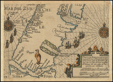
The Spanish Chart of the Strait of Magellan Reporting Its Unsuitability For Commercial Trade Routes
Scarce Spanish map of the Straits of Magellan, with a title that translates as "Reduced Chart of the Strait of Magellan, Constructed by the Commander, Officers, and Pilots of the Frigate of H.M. Sta Maria de la Cabeza. Year 1788."
The map features a scale, cartouche with flags and ornaments. It was engraved by Bartolome Vazquez.
This map stands as a prime example of 18th-century maritime cartography, particularly significant for its focus on the legendary Strait of Magellan, the crucial passageway located at the southernmost tip of South America, which was a key navigation route before the completion of the Panama Canal. Created by the Spanish naval officers and pilots aboard the frigate "Santa Maria de la Cabeza" in 1788, the map combines meticulous accuracy with elegant presentation. It illustrates the strait's winding course and adjacent landmasses, complete with depth soundings, anchoring spots, navigational hazards, and notations about the coastal landscape.
The map is grounded in the exploratory missions led by Captain Antonio de Cordoba, commissioned by the Spanish monarchy, to evaluate the feasibility of using the Strait for Spanish maritime voyages towards the Pacific. Despite their exhaustive efforts, these investigations failed to confirm the Strait's sustained usability for this purpose. Consequently, Spanish trading routes were altered, concentrating solely on the eastern ports, followed by an overland journey to the Pacific ports.
Additional valuable insights were incorporated from the records of Lieutenants Galiano and Belmonte, who were part of Cordoba's crew. In 1793, an addendum was released, which provides a comprehensive retrospective of the earlier expeditions to the region. This supplemental material is packed with an abundance of information concerning navigational guidance, climatic conditions, indigenous inhabitants, and the area's natural history.
The provided note, translated from Spanish, reads:
"NOTE: The Cape or Points whose Longitudes are observed Astronomically are marked with [symbol] in their respective places: those derived from the Bases and Angles measured from different points with [symbol] the Latitudes observed on land with a quadrant are indicated with [symbol] those observed from the sea with [symbol]; and those that have no signal are combined by alignments, and bearings."
This note sheds light on the meticulous process used to create the map, indicating different methods of observation and measurement for longitude and latitude. It signifies a careful approach to accuracy, with different symbols indicating the source and method of observation - astronomical, land-based with quadrant, or sea-based, and through alignment and bearings. It underscores the rigorous standards of 18th-century maritime cartography, reflecting the importance of these accurate charts for navigation, particularly in the treacherous waters of the Strait of Magellan.
![[Chile] Amer. Mer. No. 29. Partie Du Chili](https://storage.googleapis.com/raremaps/img/small/75812.jpg)