|
||

|

|
|

|
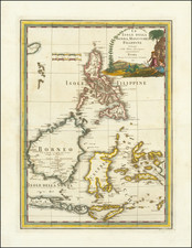
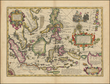
Exacting Chart of the Philippines Including Information from Malaspina’s Suppressed Expedition
Upper half of the extremely rare separately-issued general chart of the Philippine Islands, based on observations from Malaspina’s monumental scientific voyage, the results of which were stifled on his return to Spain.
The chart shows the archipelago as it was known in 1793. The main ships tracks that are coasting the islands are those of the Descubierta and the Atrevida, the Discovery and the Daring in English, which were the purpose-built corvettes made for the scientific voyage commanded by the Italian-born Malaspina on behalf of the Spanish Navy from 1789 to 1794. During the voyage, Malaspina not only oversaw the collecting of thousands of botanical and zoological samples by a team of naturalists and artists, but he also performed a detailed survey of the shores he visited, as well as recorded an unobtrusive but thorough review of the state of the Spanish empire in the Americas and the Pacific.
The chart shows as much of the archipelago as was known in the early nineteenth century, when the chart was compiled from materials from Malaspina’s expedition and from other information available to the decade-old Dirección de Hydrografía, which had been found in 1797.
Malaspina’s corvettes visited the Philippines in 1792, arriving in March and performing several forays from a base in Manila. Their course to Manila, north around Luzon, and later south, skirting Panay and Mindanao is marked here. An inset in the upper right corner of the first (northernmost) sheet also shows part of their observations near the south of the Luzon.
Malaspina’s ships are not the only voyages recorded here, however. To the west is the zig-zagging track of the frigate SM Santa Lucia in 1800. The Santa Lucia was trying to chart the tricky Scarborough Shoal, which had plagued ships and tempted states for centuries. By including its track here, the Spanish were making a claim to knowing, and therefore controlling, the waters there.
Similarly, the 1794 tracks of the schooners SM Santa Anna and San Juaquin are marked west of Cape Bolinao. The ships were in search of the shoals that supposedly existed in the area but, as the chart explains, “que no hallaron,” or they were not discovered. Their confirmed non-existence in this case meant that they would no longer be included in charts.
A title cartouche in the upper left corner of the first sheet also contains a legend explaining the symbols used on the chart. An * signals astronomical observations taken from Manila, Palapa, and Samboanga. A double cross indicates a latitude observation, while a dot with a circle around it is a longitude observation. A hand pointing shows the direction of the tracks, while sounding depths and letters telling the quality of the bottom in bays and ports give navigators vital information.
The Malaspina Expedition
As the title explains, the observations from Malaspina’s voyage provide the majority of the sources that underwrote this chart. However, this would have been one of the first charts, or indeed one of the first printed documents, to appear from that expedition.
After the large-scale scientific expedition of James Cook and La Perouse, Britain and France had asserted their imperial intentions over the Pacific. The Spanish had long operated a closed-archive policy, claiming the Pacific as their own sphere but avoiding sharing geographic information that would prove their prior exploration of the area. This was all meant to change in July 1789, when Malaspina sailed from Cádiz.
Malaspina and his fellow naval officer, José Bustamante, submitted a proposal to the Spanish Crown in 1788 outlining a grand plan, a scientific endeavor meant to gather ethnographic and natural historical information from the far reaches of the Spanish empire. The Crown approved and two new ships, the aforementioned Descubierta and Atrevida were laid in shipyards in preparation.
Alongside these scientific aims, however, were political objectives. Malaspina was to chart Spanish possessions from Montevideo to the Philippines, as well as to carry out a detailed assessment of the defensive and economic conditions of the colonies. He was also to investigate the rumored Russian settlements in California and the nascent British colony in eastern Australia.
Malaspina sailed first to Montevideo and then the Falklands, before rounding Cape Horn. The ships then worked their way up the coast, stopping at ports like Guayaquil, Callao, and Acapulco. When possible, they sent shipments of specimens and chart back to Spain, to ensure a record of the voyage was not lost if the ships were damaged or lost.
In Acapulco, Malaspina received new orders telling him to hasten to Alaska, where they were to search for a Northwest Passage first mentioned by Lorenzo Ferrer Maldonado in 1588. Malaspina thought the information was apocryphal and resented being rerouted on a wild goose chase. All Malaspina found was a short inlet leading to the Hubbard Glacier; he called it Puerto de Desengaño, or Deceit Passage.
By the end of 1791, Malaspina was back in Acapulco, readying to sail across the Pacific. They stopped first at Guam, in the Marianas, and then came to the Philippines, the part of the voyage chronicled in this chart. Malaspina spent nearly nine months in the Philippines, while Bustamante took the Atrevida to Macao, a part of the voyage not shown here.
From the Philippines, the ships set out into the open Pacific. They briefly visited New Zealand and then spent a month at Port Jackson in Australia, where they made important observations of the penal settlement. Malaspina then charted Vava’u, in the Tongan archipelago, claiming it for Spain.
The ships returned to Callao and coasted south to Cape Horn once again. In the meantime, war had broken out with France. Malaspina decided to send his ships back separately to Montevideo, to lessen the chance that they would both be captured. They then returned together in consort with a frigate and trading vessels to Spain in September 1794, just over five years after they had left.
The lack of publication of the Malaspina expedition
Upon his return, Malaspina was disappointed at the lack of attention he and his fellow officers received. Spain was at war with France, and Malaspina quickly expressed his opinions about the political situation. He was also preparing the masses of reports, charts, and documents into what he planned as a seven-part voyage account complete with a hydrographic atlas and a folio-sized book of drawings.
This grand plan was never to be, however, as Malaspina was implicated in a conspiracy to topple the first minister, Manuel Godoy. Tried in absentia, Malaspina was sentenced to ten years in prison. He and his fellow officers were also ordered to stop work on the voyage account; they had to return all papers having to do with the expedition to the state.
The only one of the seven volumes planned by Malaspina that was published was of a subsidiary survey of the Strait of Juan de Fuca performed by Dionisio Alcalá Galiano and Cayetano Valdés. This work was intended to counter the claims posited in George Vancouver’s voyage account, published in 1798, but the Galiano and Valdés book was too little, despite including a fine atlas, and four years too late. Malaspina was not mentioned in the work; he was referred to only as the anonymous “commander of the corvettes.” While many of the botanical samples made it to the Real Jardín Botánico, few of the voyage artists and naturalists published their work.
The only information that was published were the hydrographic observations, which are related to this chart. In 1809, Don Josef Espinosa y Tello published Memorias sobre las observaciones astronómicas, hechas por los navegantes españoles en distintos lugares del globo. Espinosa y Tello had served on the Malaspina expedition, joining them belatedly at Acapulco. In 1797 he was appointed as the first head of the Dirección de Hydrografía, a position he held until 1808, when this chart was published by that office. In the Memorias, Espinosa y Tello mentions Malaspina by name and used his journal in the Memoria Segunda, which covered the Americas and the Pacific.
Surprisingly, the suppression of Malaspina was so complete that the first publication of his journal was in Russian. It appeared as a serialized story in a Russian naval journal from 1824 to 1827, having been translated from Spanish to French to Russian. It was published in Spanish only in 1885, in a heavily abridged and edited edition by Pedro Novo y Colson. The entirety of Malaspina’s journal, with supporting documents, was only published in 1990 in a nine-volume set that rightly returned Malaspina to a place of honor in the history of Pacific exploration.
This chart, then, was one of the first printed charts to publicly acknowledge the important voyage of Malaspina. It showed the Philippines in more detail and with more transparency than previous charts and is a significant and rare document in the history of Pacific navigation.
Rarity
OCLC only lists examples at the British Library, the Biblioteca Nacional de España, and the American Geographic Society collection at the University of Wisconsin-Milwaukee.
The Dirección de Hidrografía, or the Directorate of Hydrographic Works, was established in 1797. Its roots were in the Casa de Contratación, founded in 1503 in Sevilla, which housed all the charts of the Spanish Empire and oversaw the creation and maintenance of the padrón real, the official master chart. The Casa, now in Cadiz, was shuttered in 1790, but Spain still needed a hydrographic body. In response, the Dirección was created in 1797. One of its first projects was the publication of charts from the Malaspina Expedition (1789-1794). The Dirección oversaw not only publication, but also surveying. The Dirección was abolished in the early twentieth century, when their work was distributed to other organizations.