
The item illustrated and described below is sold, but we
have another example in stock. To view the example which
is currently being offered for sale, click the
"View Details" button below.


|
||

|

|
|

|
Stock# 9226
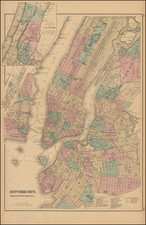
Description
Attractive large format map of New York City and Vicinity, extending north to East 125th Street and showing all of Central Park. Extremely detailed map, showing streets, buildings, rail lines, wharfs, ferrys, Islands, etc. Colored by wards. Large inset map of Northern portion of the City, extending to Yonkers. Extensive key lists dozens of places in the various cities. Gray's National Atlas was one of the most successful commercial ventures of the 1870s and one of the last to employ hand coloring on maps. Minor fold split on left and right extends about 1 inch into image.