|
||

|

|
|

|
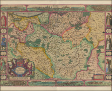
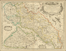
"Poland," a map produced by John Seller in 1679, accurately represents the region of Poland during a notable period of its history. As part of the Atlas Minimus, this map serves as a testament to the geographical understanding and cartographic standards of the late 17th century.
The map delineates Poland, a nation with a complex geographic and cultural landscape. During this time, the Polish-Lithuanian Commonwealth, a major political entity in central and eastern Europe, was in operation.
The map indicates significant geographical markers and political boundaries. It reflects the administrative divisions of the era, providing insight into the geopolitical landscape of 17th-century Poland.
Accompanying the map, an engraved table titled "These VI Countries are Subject to the Crown of Poland" lists the primary divisions within the Polish realm, including "The great Dukedom of Lithuania," "The Ukrain or Country of the Cosaques," "The Duchy of Prussia," "The Duchy of Courland," and "Samogitia."
John Seller's "Poland" map provides a comprehensive geographical representation of the region during the late 17th century. The accompanying table of countries under the Polish Crown further contextualises the map, offering insights into the political structure of the region during this period.
John Seller was one of the most notable map and instrument makers in England in the late-seventeenth century. He was especially known for the sea charts, many of which featured in his influential English Pilot and Atlas Maritimus. Seller was born in London in 1632. His father was a cordwainer and John was apprenticed to Edward Lowe, of the Merchant Taylors’ Company. He was made free of that company in 1654. Later, he also was made a brother of the Clockmakers’ Company, which housed several instrument makers. He started business as a compass maker but expanded his offering to include navigational instruments and charts.
Seller’s career was halted temporarily, and fantastically, when he was tried for high treason in 1662. He was accused of involvement in a plot led by Thomas Tonge. While Seller likely only unwisely repeated rumors, he was convicted. The other conspirators, who did admit some degree of guilt, were executed, but Seller maintained his innocence and, via insistent petitions, he eventually secured his release from Newgate Prison.
This episode did not seem to slow Seller’s rise too much, however. Seller was granted a royal license to publish English-language maritime atlases. This gave him a near-monopoly and led to his being named hydrographer to the King in 1671. Although the point of the project was to produce English charts of Dutch dominance and bias, Seller ended up using many Dutch plates as his base material. The first volume of The English Pilot was published in 1671, followed by more volumes as well as The Coating Pilot (1672) and the Atlas Maritimus (1675). Seller was commercially successful, but some of his projects required further support. The English Pilot was eventually taken over by John Thornton and William Fisher, for example, and his proposed English atlas only produced maps of six counties.
Seller’s sons, John and Jeremiah, followed in their father’s profession. Seller also apprenticed several promising young men, including Charles Price, with whom his sons partnered. Through Price, Seller can be seen as the founding figure of an important group of London mapmakers that included Price, John Senex, Emanuel Bowen, Thomas Kitchin, and Thomas Jefferys.
![[Gdansk] La Ville de: Danzic, dans la Prusse Royale.](https://storage.googleapis.com/raremaps/img/small/85303.jpg)