|
||

|

|
|

|
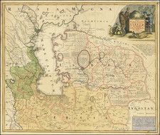
Moscovia, a 1679 map by John Seller, presents a captivating depiction of a region extending from the Black Sea to the Caspian, and includes an early representation of Nova Zemla attached to the mainland. Published in London and included in the Atlas Minimus, this map reflects the cartographic understanding and artistic style of the late 17th century.
The latter half of the 17th century was a period of significant cartographic development, and John Seller, a prominent English instrument maker, cartographer, and publisher, was at the forefront of these advancements. Moscovia is a testament to his work, offering a glimpse into the geographical knowledge of the period. The map intriguingly shows "Greenland," which, given the geographical context, most likely refers to Svalbard.
The map is accompanied by a detailed list of regional names. This list, titled "Moscovy or The Great and White Russia is Triply Divided into," provides a comprehensive enumeration of "Kingdoms," "Duchies," and "Hoords Comonalties of Tartars." Such a categorization not only reflects the political divisions of the time but also gives insight into the ethnographic understanding of the period.
Moscovia is a fascinating piece not only for its geographical depiction but also for the sociopolitical context it provides. The map, with its remarkable representation of a significant European and Asian region, and the accompanying list of regional names, together constitute an important snapshot of the late 17th-century understanding of this part of the world.
John Seller was one of the most notable map and instrument makers in England in the late-seventeenth century. He was especially known for the sea charts, many of which featured in his influential English Pilot and Atlas Maritimus. Seller was born in London in 1632. His father was a cordwainer and John was apprenticed to Edward Lowe, of the Merchant Taylors’ Company. He was made free of that company in 1654. Later, he also was made a brother of the Clockmakers’ Company, which housed several instrument makers. He started business as a compass maker but expanded his offering to include navigational instruments and charts.
Seller’s career was halted temporarily, and fantastically, when he was tried for high treason in 1662. He was accused of involvement in a plot led by Thomas Tonge. While Seller likely only unwisely repeated rumors, he was convicted. The other conspirators, who did admit some degree of guilt, were executed, but Seller maintained his innocence and, via insistent petitions, he eventually secured his release from Newgate Prison.
This episode did not seem to slow Seller’s rise too much, however. Seller was granted a royal license to publish English-language maritime atlases. This gave him a near-monopoly and led to his being named hydrographer to the King in 1671. Although the point of the project was to produce English charts of Dutch dominance and bias, Seller ended up using many Dutch plates as his base material. The first volume of The English Pilot was published in 1671, followed by more volumes as well as The Coating Pilot (1672) and the Atlas Maritimus (1675). Seller was commercially successful, but some of his projects required further support. The English Pilot was eventually taken over by John Thornton and William Fisher, for example, and his proposed English atlas only produced maps of six counties.
Seller’s sons, John and Jeremiah, followed in their father’s profession. Seller also apprenticed several promising young men, including Charles Price, with whom his sons partnered. Through Price, Seller can be seen as the founding figure of an important group of London mapmakers that included Price, John Senex, Emanuel Bowen, Thomas Kitchin, and Thomas Jefferys.
![Livoniae Provinciae Ac Eivs [with] Moscoviae Maximi Amplissimi Que Ducatus](https://storage.googleapis.com/raremaps/img/small/75324.jpg)