|
||

|

|
|

|
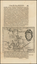
A rare early miniature English map of Asia, featured in John Seller's Atlas Minimus or a Book of Geography Shewing all the Empires, Monarchies, Kingdomes, Regions, Dominions Principalities and Countries of the World, offering a unique perspective on the geography of the continent during the 17th century.
John Seller's Atlas Minimus, published in the late 17th century, is among the most sought-after and rare miniature atlases, with the last complete example to appear at auction being the Wardington copy in 2006.
This fascinating map of Asia provides a snapshot of the understanding of the continent's geography at the time, including regions such as Turkey in Asia, Georgia, Arabia, Persia, Tartary, and China. The map is accompanied by an engraved toponym key facing the map.
The text below the map offers insight into the contemporary perception of Asia's boundaries and its historical significance. It describes Asia as being bounded by Europe to the west, the Main Scythick Ocean to the north, the supposed Straits of Anian to the east, and part of the Mediterranean, etc. to the south. The text highlights the region's importance as the location of the Garden of Eden and "the birthplace of our Savior," as well as the center of power for various ancient empires, such as the Assyrians, Babylonians, Medes, and Persians.
The people of Asia are described as being "generally of a swarthy complexion" and adhering to either "Pagan or Mahometan" faiths. The map also mentions the significant rulers of the time, including the Tartars to the north, the Turks to the south and west, and the Chinese and Japanese to the east.
John Seller was one of the most notable map and instrument makers in England in the late-seventeenth century. He was especially known for the sea charts, many of which featured in his influential English Pilot and Atlas Maritimus. Seller was born in London in 1632. His father was a cordwainer and John was apprenticed to Edward Lowe, of the Merchant Taylors’ Company. He was made free of that company in 1654. Later, he also was made a brother of the Clockmakers’ Company, which housed several instrument makers. He started business as a compass maker but expanded his offering to include navigational instruments and charts.
Seller’s career was halted temporarily, and fantastically, when he was tried for high treason in 1662. He was accused of involvement in a plot led by Thomas Tonge. While Seller likely only unwisely repeated rumors, he was convicted. The other conspirators, who did admit some degree of guilt, were executed, but Seller maintained his innocence and, via insistent petitions, he eventually secured his release from Newgate Prison.
This episode did not seem to slow Seller’s rise too much, however. Seller was granted a royal license to publish English-language maritime atlases. This gave him a near-monopoly and led to his being named hydrographer to the King in 1671. Although the point of the project was to produce English charts of Dutch dominance and bias, Seller ended up using many Dutch plates as his base material. The first volume of The English Pilot was published in 1671, followed by more volumes as well as The Coating Pilot (1672) and the Atlas Maritimus (1675). Seller was commercially successful, but some of his projects required further support. The English Pilot was eventually taken over by John Thornton and William Fisher, for example, and his proposed English atlas only produced maps of six counties.
Seller’s sons, John and Jeremiah, followed in their father’s profession. Seller also apprenticed several promising young men, including Charles Price, with whom his sons partnered. Through Price, Seller can be seen as the founding figure of an important group of London mapmakers that included Price, John Senex, Emanuel Bowen, Thomas Kitchin, and Thomas Jefferys.