


|
||

|

|
|

|
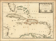
John Seller's Terra Firma is an exquisite map from the Atlas Minimus, published in London in 1679. John Seller was a renowned English cartographer and instrument maker of the 17th century.
The map presents a fascinating view of the northern part of South America and a significant portion of the Caribbean, including Florida. One of the striking features of this map is its orientation: west is placed at the top, suggesting the perspective of an observer approaching from across the Atlantic Ocean. This unique perspective aligns with the historical context of the time, as European voyages to the Americas were primarily from east to west.
The left side of the map presents a meticulously engraved table, listing the political divisions within the depicted region of northern South America. These divisions provide insight into the geopolitical landscape of the time, reflecting the territorial claims and administrative structures established by European colonial powers.
As a historical document, the "Terra Firma" map provides invaluable insights into the perceptions and knowledge of the Americas in the late 17th century. It reflects the era's advancements in cartography, as well as the geopolitical implications of European colonialism in the New World.
John Seller was one of the most notable map and instrument makers in England in the late-seventeenth century. He was especially known for the sea charts, many of which featured in his influential English Pilot and Atlas Maritimus. Seller was born in London in 1632. His father was a cordwainer and John was apprenticed to Edward Lowe, of the Merchant Taylors’ Company. He was made free of that company in 1654. Later, he also was made a brother of the Clockmakers’ Company, which housed several instrument makers. He started business as a compass maker but expanded his offering to include navigational instruments and charts.
Seller’s career was halted temporarily, and fantastically, when he was tried for high treason in 1662. He was accused of involvement in a plot led by Thomas Tonge. While Seller likely only unwisely repeated rumors, he was convicted. The other conspirators, who did admit some degree of guilt, were executed, but Seller maintained his innocence and, via insistent petitions, he eventually secured his release from Newgate Prison.
This episode did not seem to slow Seller’s rise too much, however. Seller was granted a royal license to publish English-language maritime atlases. This gave him a near-monopoly and led to his being named hydrographer to the King in 1671. Although the point of the project was to produce English charts of Dutch dominance and bias, Seller ended up using many Dutch plates as his base material. The first volume of The English Pilot was published in 1671, followed by more volumes as well as The Coating Pilot (1672) and the Atlas Maritimus (1675). Seller was commercially successful, but some of his projects required further support. The English Pilot was eventually taken over by John Thornton and William Fisher, for example, and his proposed English atlas only produced maps of six counties.
Seller’s sons, John and Jeremiah, followed in their father’s profession. Seller also apprenticed several promising young men, including Charles Price, with whom his sons partnered. Through Price, Seller can be seen as the founding figure of an important group of London mapmakers that included Price, John Senex, Emanuel Bowen, Thomas Kitchin, and Thomas Jefferys.

![[Rare Blaeu West Indische Pascaert Wall Map Section] Insulae Americanae in Oceano Septentrionali, cum terris adjacentibus](https://storage.googleapis.com/raremaps/img/small/75672.jpg)
![The West India Islands, and Central America [with] Jamaica](https://storage.googleapis.com/raremaps/img/small/78675.jpg)